


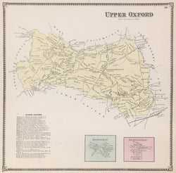
A.R. Witmer. “Upper Oxford, Homeville, Russelville.” From Atlas of Chester County.
Safe Harbor, Lancaster Co., PA: A.R. Witmer, 1873. 14 x 14 (decorative border). Lithograph. Original hand color.
Starting about 1870, atlases and maps of counties, townships and specific properties in the Philadelphia suburbs began to be published by such firms as Bromley, Hopkins, Mueller, Witmer and Breous. Their output has provided us with excellent, detailed images of the growth from the 1870s through the first half of the twentieth century. These atlases were used for planning, government purposes, and just for the information of citizens of the area. These atlases are also known as ‘railroad, real estate, and/or insurance’ atlases and contained very accurate and detailed information such as streets, properties, parks, and other topographical and social features.
 %20%0A%20%0Ahttps://philaprintshop.com/products/witmer-a-r-upper-oxford-homeville-russelville-from-atlas-of-chester-county %20%0A%20%0AWitmer,%20A.R.%20%20%E2%80%9CUpper%20Oxford,%20Homeville,%20Russelville.%E2%80%9D%20From%20%22Atlas%20of%20Chester%20County%22 %20%0A%20%0A//philaprintshop.com/cdn/shop/products/upperoxfordwitmerc_1024x1024.jpg?v=1658868649 %20%0A%20%0AAntique Prints, Maps, Drawings, Paintings and Rare Books! %20%0A%20%0AThe Philadelphia Print Shop %20%0A106 E. Lancaster Avenue, Lower Level %20%0AWayne, PA 19087 %20%0A%20%0APhilaPrintShop.com %20%0A@PhiladelphiaPrintShop %20%0A 610 (808) 6165)