


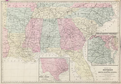
W. Williams. “Map of the Southern and South-Western States.” With two inset maps of Eastern Virginia and Texas. From Appleton’s Hand Book of American Travel.
New York: Appleton, 1849. 12 x 17 ¼ Lithograph. Original hand color. With fold as originally issued. Couple repaired tears right hand side and filled chipped margin. Good condition.
“To meet the increased and steadily increasing demand for a reliable Tourists’ Guide and Hand-Book of Travel in the United States and British Provinces, this work has been specially prepared, and will hereafter be published annually on the 1st of May.” (v.) This is the annual edition for 1867, and it is very informative about the United States and travel about it at that time. Each state has its own descriptive section, and there is a separate chapter on Canada. Filled with excellent folding maps of the regions and cities of North America, as well as numerous advertisements for hotels, clothiers, passenger lines, and so on, this is a delightful and educational document of mid-nineteenth century America.
 %20%0A%20%0Ahttps://philaprintshop.com/products/williams-w-map-of-the-southern-and-south-western-states %20%0A%20%0AWilliams,%20W.%20%20%E2%80%9CMap%20of%20the%20Southern%20and%20South-Western%20States%22 %20%0A%20%0A//philaprintshop.com/cdn/shop/products/appletonsouthernstatesc_1024x1024.jpg?v=1651866926 %20%0A%20%0AAntique Prints, Maps, Drawings, Paintings and Rare Books! %20%0A%20%0AThe Philadelphia Print Shop %20%0A106 E. Lancaster Avenue, Lower Level %20%0AWayne, PA 19087 %20%0A%20%0APhilaPrintShop.com %20%0A@PhiladelphiaPrintShop %20%0A 610 (808) 6165)