


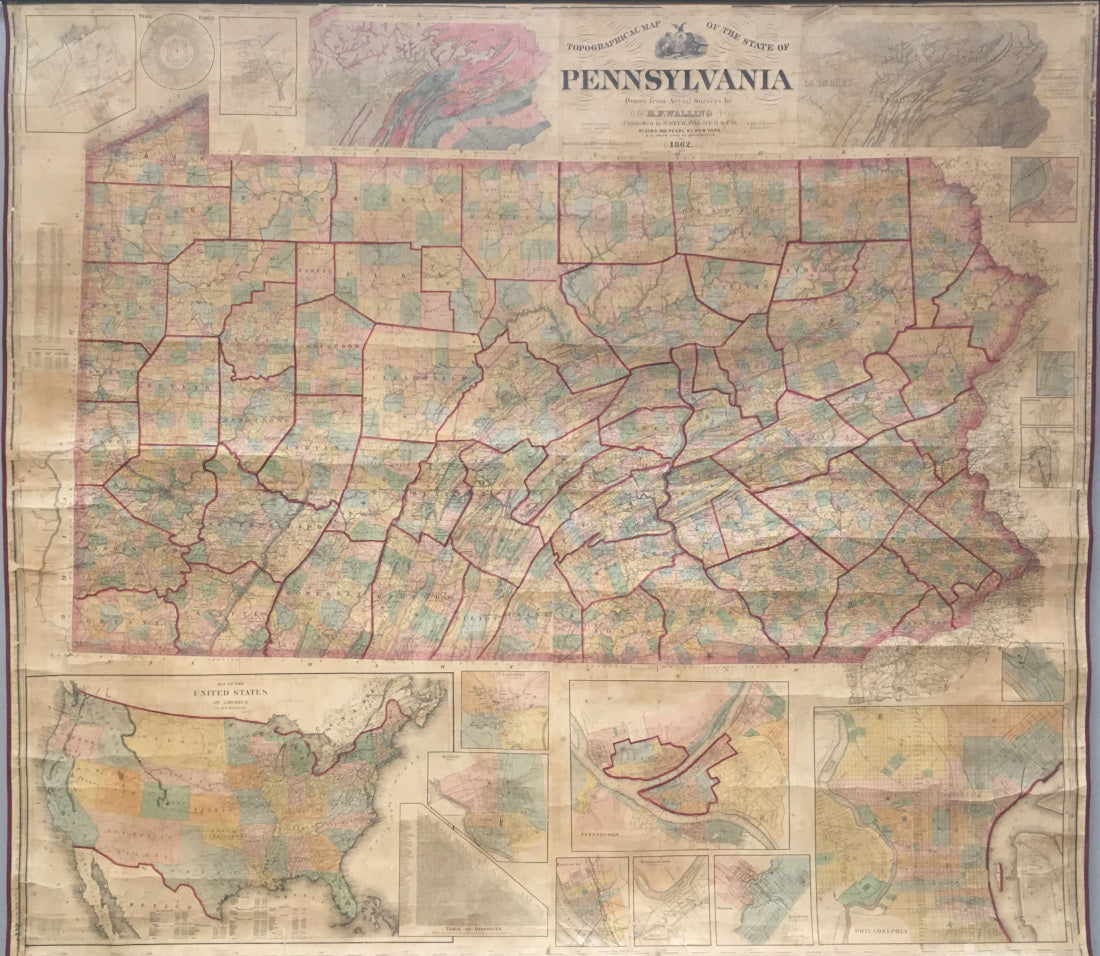
H.F. Walling. "Topographical Map of the State of Pennsylvania. Drawn from Actual Surveys by H. F. Walling."
New York: Smith, Palmer, & Co., 1862. 63 x 71. Lithograph. Original hand color. Several small losses, professionally repaired and conserved. Slight misalignment along center seam. Otherwise, very good condition.
A wonderfully informative wall map by H.F Walling. Made during the Civil War, the state of Pennsylvania is handsomely depicted and is surrounded by insets of all of the state's major cities at the time; Philadelphia, Pittsburgh, Lancaster, Reading, Scranton, Harrisburg, Erie, Pottsville, Wilkesbarre, Honesdale, Montrose, Carbondale, Pittston.
The entire United States, depicted as united even during the war, is also illustrated in the lower left which includes a table of distances between cities. Numerous other charts are also shown, including, both a climatological and topographical map, a time table, and a population chart. A fascinating and beautiful map from a tumultuous time.

 %20%0A%20%0Ahttps://philaprintshop.com/products/walling-h-f-topographical-map-of-the-state-of-pennsylvania-drawn-from-actual-surveys-by-h-f-walling %20%0A%20%0AWalling,%20H.F.%20%22Topographical%20Map%20of%20the%20State%20of%20Pennsylvania.%20Drawn%20from%20Actual%20Surveys%20by%20H.%20F.%20Walling%22 %20%0A%20%0A//philaprintshop.com/cdn/shop/products/wallingpa1862c_1024x1024.jpg?v=1649184651 %20%0A%20%0AAntique Prints, Maps, Drawings, Paintings and Rare Books! %20%0A%20%0AThe Philadelphia Print Shop %20%0A106 E. Lancaster Avenue, Lower Level %20%0AWayne, PA 19087 %20%0A%20%0APhilaPrintShop.com %20%0A@PhiladelphiaPrintShop %20%0A 610 (808) 6165)