


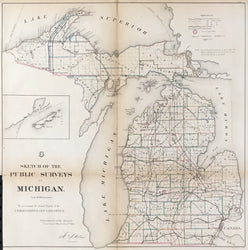
Unattributed. "Sketch of the Public Surveys in Michigan."
Washington: General Land Office, 1866. 20 3/4 x 20 1/2. Lithograph by Bowen & Co. Original outline color. Some slight separation and wear on vertical fold. Else, very good condition.
The U.S. General Land Office (GLO) was established in 1812 with responsibility to survey and control the dispersal of public lands. All public land was required to be surveyed prior to settlement, and the first director of the GLO, Thomas Hutchins, set up a systematic process of rectangular survey for the public lands and launched the great national project to survey and map the public domain in the entire country, a procedure which got under way in the famous "seven ranges" of southeast Ohio. Each surveyor was to record not only geography, but also features of the landscape with economic import, such as roads, Indian trails, existing settlements, Indian lands, mineral deposits, and of particular interest, railroads and their rights of way. Of note is that unlike most surveys of the time, the surveyors were instructed not to apply new names to the landscape, but to use "the received names of all rivers, creeks, lakes, swamps, prairies, hills, mountains and other natural objects." Periodically the GLO would issue maps showing the progress of their surveys, and this map shows how Michigan was well covered by 1866. Interesting features are the many railroads in the state, as well as in lead and copper mines indicated in the northwest.
 %20%0A%20%0Ahttps://philaprintshop.com/products/unattributed-sketch-of-the-public-surveys-in-michigan-1 %20%0A%20%0AUnattributed%20%20%22Sketch%20of%20the%20Public%20Surveys%20in%20Michigan%22 %20%0A%20%0A//philaprintshop.com/cdn/shop/products/glomichiganc_1024x1024.jpg?v=1653425173 %20%0A%20%0AAntique Prints, Maps, Drawings, Paintings and Rare Books! %20%0A%20%0AThe Philadelphia Print Shop %20%0A106 E. Lancaster Avenue, Lower Level %20%0AWayne, PA 19087 %20%0A%20%0APhilaPrintShop.com %20%0A@PhiladelphiaPrintShop %20%0A 610 (808) 6165)