
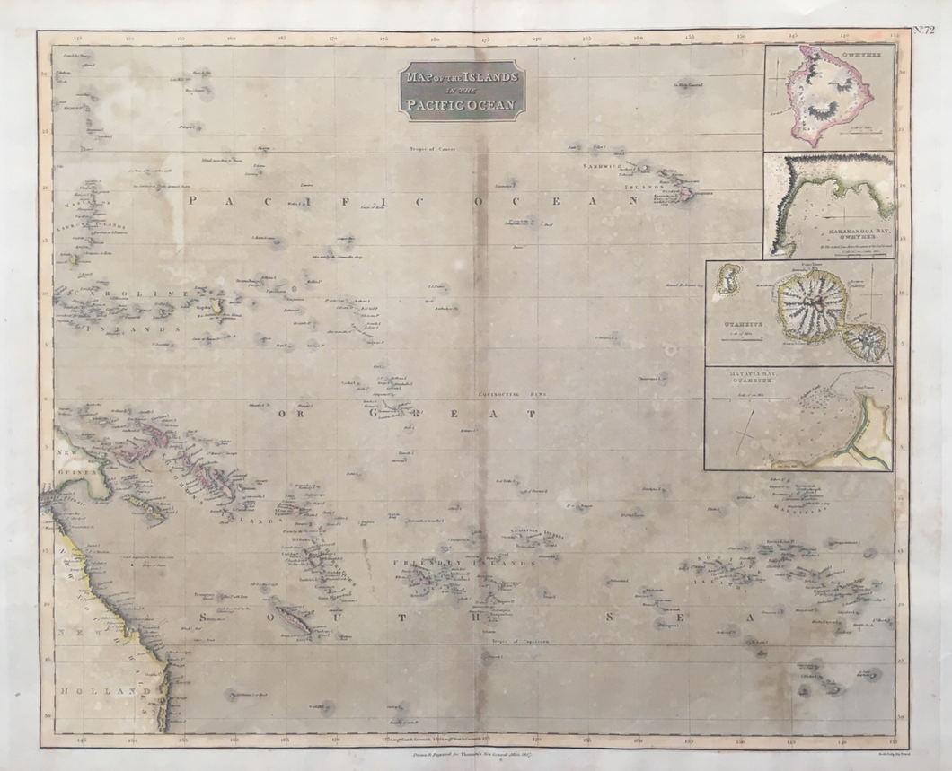
John Thomson. "Map of the Islands in the Pacific Ocean". From A New General Atlas.
Edinburgh: J. Thomson, 1817. 19 3/8 x 23 1/2. Engraving by Neele. Original hand color. Full margins. Browned. Otherwise, good condition.
This map shows the islands of the Pacific, from the Caroline Islands to Hawaii. The detail is excellent, including most actual islands and many non-existent ones. Non-existent islands have been denizens of charts and maps from the very beginning. The sources of these islands are manifold, including legend, folklore, incorrect navigation, fraud, and so on. Amongst the most famous legendary islands are Rica de Plata and Rica de Oro, or the Islands of Silver and Gold, said to be located between Japan and California. The former does not appear, but the latter is shown just to the east of another non-existent island, Lots Wife.
Despite its inclusion of many fictional islands, Thomson was very concerned with either excluding such islands or at least indicating some doubt about them. In several places Thomson indicates an island "seen by...," "Is. Doubtful," and in one place he notes "It is doubtful if those Islands are in existence." The Pacific Ocean is a vast area, and it was only in the late eighteenth century that navigational tools enabled consistently accurate readings. Thus it is not surprising that it took a very long time to correct the many errors in its mapping. This is an instructive and fascinating stage in the history of this process.
 %20%0A%20%0Ahttps://philaprintshop.com/products/thomson-john-map-of-the-islands-in-the-pacific-ocean %20%0A%20%0AThomson,%20John%20%22Map%20of%20the%20Islands%20in%20the%20Pacific%20Ocean%22 %20%0A%20%0A//philaprintshop.com/cdn/shop/products/ScreenShot2021-04-12at2.29.24PM_1024x1024.png?v=1618259505 %20%0A%20%0AAntique Prints, Maps, Drawings, Paintings and Rare Books! %20%0A%20%0AThe Philadelphia Print Shop %20%0A106 E. Lancaster Avenue, Lower Level %20%0AWayne, PA 19087 %20%0A%20%0APhilaPrintShop.com %20%0A@PhiladelphiaPrintShop %20%0A 610 (808) 6165)