![Thomson, John “Holland.” [Netherlands]](http://philaprintshop.com/cdn/shop/products/thomson-hollandc_{width}x.jpg?v=1677606935)
![Thomson, John “Holland.” [Netherlands]](http://philaprintshop.com/cdn/shop/products/thomson-holland_{width}x.jpg?v=1677606939)
![Thomson, John “Holland.” [Netherlands]](http://philaprintshop.com/cdn/shop/products/thomson-hollandc_530x@2x.jpg?v=1677606935)
![Load image into Gallery viewer, Thomson, John “Holland.” [Netherlands]](http://philaprintshop.com/cdn/shop/products/thomson-hollandc_1024x1024@2x.jpg?v=1677606935)
![Load image into Gallery viewer, Thomson, John “Holland.” [Netherlands]](http://philaprintshop.com/cdn/shop/products/thomson-holland_1024x1024@2x.jpg?v=1677606939)
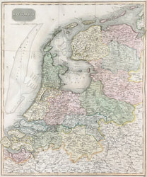
John Thomson (1777-c. 1840). “Holland.” [Netherlands]
Edinburgh: J. Thomson, 1814. From A New General Atlas. 17 5/8 x 23 1/2. Full original hand color. Narrow margin right hand side. Else, very good condition.
A strong and accurate map published by Scottish cartographer John Thomson. The quality of British cartographic production was not limited to London, and this map is good evidence that superb maps were issued to the north as well. Towns are carefully named and the attention is given to geographical detail of regions and rivers is impressive. The delicate hand coloring highlights the information given, making the map both easier to read and pleasing to look at. Altogether, a fine example of early 19th-century British cartography.
 %20%0A%20%0Ahttps://philaprintshop.com/products/thomson-john-holland-netherlands %20%0A%20%0AThomson,%20John%20%E2%80%9CHolland.%E2%80%9D%20%20[Netherlands] %20%0A%20%0A//philaprintshop.com/cdn/shop/products/thomson-hollandc_1024x1024.jpg?v=1677606935 %20%0A%20%0AAntique Prints, Maps, Drawings, Paintings and Rare Books! %20%0A%20%0AThe Philadelphia Print Shop %20%0A106 E. Lancaster Avenue, Lower Level %20%0AWayne, PA 19087 %20%0A%20%0APhilaPrintShop.com %20%0A@PhiladelphiaPrintShop %20%0A 610 (808) 6165)