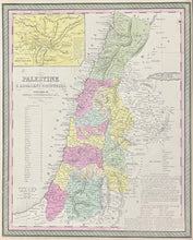
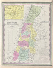
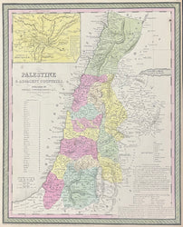
"Palestine & Adjacent Countries."
Philadelphia: Thomas Cowperthwait, & Co, 1850. 15 5/8 x 12 3/4. Lithograph. Original hand color. Very good condition.
A very informative map of Palestine by Thomas, Cowperthwait & Co. The country is broken up into its Turkish provinces with a listing of all thirty eight of them. Palestine, along with many countries in the area, was part of the Ottoman empire starting in 1516 and not ending until World War I. This map also includes a map of the environs of Jerusalem, a list of the ten cities of the Decapolis, icons representing towns mentioned the sacred scripture, the ancient and modern names of many cities, and an explanation of Arabic appellatives. Finally, there is a notation of the new measurements and exploration of the Dead Sea which is "smaller than usually represented."


