

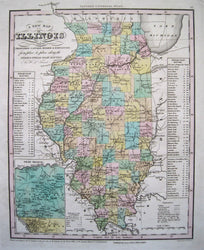
Henry S. Tanner. "A New Map of Illinois with its Proposed Canals, Roads & Distances from place to place along the Stage and Steam Boat Routes". From Tanner's Universal Atlas.
Philadelphia: Carey & Hart, 1843. 13 1/4 x 10 1/2. Engraving. Original hand color. Very good condition.
A strong and beautifully crafted map of Illinois from the nineteenth century by the great American cartographer, Henry Schenck Tanner. In 1816, Henry, his brother Benjamin, John Vallance and Francis Kearny formed an engraving firm in Philadelphia. Having had experience at map engraving through his work with John Melish, Tanner conceived of the idea of compiling and publishing an American Atlas, which was begun in 1819 by Tanner, Vallance, Kearny & Co. Soon Tanner took over the project on his own, and thus began his career as cartographic publisher. The American Atlas was a huge success, and this inspired Tanner to produce his Universal Atlas, of more manageable size. This atlas contained excellent maps of each state, focusing on the transportation network, including roads, railroads and canals. This map is a fine example of that atlas. This map shows Illinois at an interesting period in its history, and is filled with myriad topographical details, including rivers, towns, and political borders. The Tanner maps are especially known for their depiction of the transportation routes of the states, and this map is no exception. The transportation infrastructure was extremely important at this period of increased immigration and travel in the United States. This information is clearly depicted, including roads and both existing and proposed rail lines and canals. Tables to the right and left list the steam boat routes and distances between stops. A very interesting inset shows the "Lead Region" of Wisconsin and northern Illinois, with an explanatory reference key.
 %20%0A%20%0Ahttps://philaprintshop.com/products/tanner-henry-schenck-a-new-map-of-illinois-with-its-proposed-canals-roads-distances-from-place-to-place-along-the-stage-and-steam-boat-routes %20%0A%20%0ATanner,%20Henry%20Schenck%20%20%22A%20New%20Map%20of%20Illinois%20with%20its%20Proposed%20Canals,%20Roads%20%26%20Distances%20from%20place%20to%20place%20along%20the%20Stage%20and%20Steam%20Boat%20Routes%22 %20%0A%20%0A//philaprintshop.com/cdn/shop/products/carhart43il_1024x1024.jpg?v=1618523798 %20%0A%20%0AAntique Prints, Maps, Drawings, Paintings and Rare Books! %20%0A%20%0AThe Philadelphia Print Shop %20%0A106 E. Lancaster Avenue, Lower Level %20%0AWayne, PA 19087 %20%0A%20%0APhilaPrintShop.com %20%0A@PhiladelphiaPrintShop %20%0A 610 (808) 6165)