


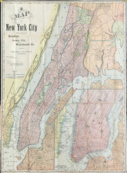
Rand McNally. “New York, Brooklyn and Jersey City and Westchester.”
Chicago: Rand McNally, 1892. 26 x 19. Color cerograph. Folding map with worn cover and two small holes in folds filled and in-painted. With folds as issued. Good condition.
A late nineteenth century map from the early days of the Rand, McNally & Co. firm out of Chicago, a company that would shift the center of cartographic publishing from the east coast to the mid-west. Typical of the firm’s work, this map has very good detail precisely and neatly exhibited. Topographic and social information about the city are neatly illustrated. Aesthetically and cartographically, it foreshadows the maps of the twentieth century. A lovely and colorful map of the city.
 %20%0A%20%0Ahttps://philaprintshop.com/products/rand-mcnally-newyork-brooklyn-and-jersey-city-and-westchester %20%0A%20%0ARand%20McNally.%20%20%E2%80%9CNew%20York,%20Brooklyn%20and%20Jersey%20City%20and%20Westchester.%E2%80%9D%20Folding%20map %20%0A%20%0A//philaprintshop.com/cdn/shop/products/randnyc1892c_1024x1024.jpg?v=1645205510 %20%0A%20%0AAntique Prints, Maps, Drawings, Paintings and Rare Books! %20%0A%20%0AThe Philadelphia Print Shop %20%0A106 E. Lancaster Avenue, Lower Level %20%0AWayne, PA 19087 %20%0A%20%0APhilaPrintShop.com %20%0A@PhiladelphiaPrintShop %20%0A 610 (808) 6165)