


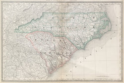
Rand, McNally. “Map of North and South Carolina.”
Chicago: Rand, McNally & Co., 1880. 12 ¾ x 19 ¼. Cerograph. Full original color. Very good condition.
A nineteenth century map from the Rand, McNally & Co. firm out of Chicago, a company that would shift the center of cartographic publishing from the east coast to the mid-west. Typical of the firm’s work, this map has very good detail precisely and neatly exhibited. Topographic and social information, counties, roads, and many more details are neatly illustrated. Also of note, every major railroad line is delineated. All in all, aesthetically and cartographically pleasing.
 %20%0A%20%0Ahttps://philaprintshop.com/products/rand-mcnally-map-of-north-and-south-carolina %20%0A%20%0ARand%20McNally%20%20%22Map%20of%20North%20and%20South%20Carolina%22 %20%0A%20%0A//philaprintshop.com/cdn/shop/files/randnscarolina1880c_1024x1024.jpg?v=1685652729 %20%0A%20%0AAntique Prints, Maps, Drawings, Paintings and Rare Books! %20%0A%20%0AThe Philadelphia Print Shop %20%0A106 E. Lancaster Avenue, Lower Level %20%0AWayne, PA 19087 %20%0A%20%0APhilaPrintShop.com %20%0A@PhiladelphiaPrintShop %20%0A 610 (808) 6165)