


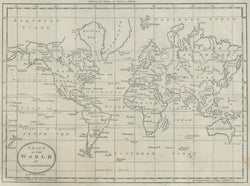
Jedidiah Morse. “Chart Of The World On Mercators Projection.” From Jedidiah Morse’s The American Universal Geography.
Boston: Thomas & Andrews, 1796. 7 1/4 x 9 3/4. Engraving by A. Doolittle. Very small abrasion in map surface in lettering of “New Foundland.” Else, very good condition. Wheat & Brun: 31.
An excellent late eighteenth century map of the world on the Mercator Projection. This map was from Jedidiah Morse’s Geography, one of the first American publications of its kind. Morse, the father of Samuel F.B. Morse, established himself in the 1780s as one of the leading producers of American maps. Doolittle, the engraver, is one of the great names in American engraving, especially during the Revolution. The islands noted throughout are quite interesting. Also of interest is the non-existent “West River” shown in North America extending from a lake in the north-central plains to “Nootka Sound” on the Pacific coast. Also of note is the depiction of “McKenses R.” in northwest Canada.
 %20%0A%20%0Ahttps://philaprintshop.com/products/morse-jedidiah-map-of-the-world-from-the-best-authorities %20%0A%20%0AMorse,%20Jedidiah%20%E2%80%9CChart%20Of%20The%20World%20On%20Mercators%20Projection.%E2%80%9D %20%0A%20%0A//philaprintshop.com/cdn/shop/products/worldthomasandrews1796c_1024x1024.jpg?v=1632934249 %20%0A%20%0AAntique Prints, Maps, Drawings, Paintings and Rare Books! %20%0A%20%0AThe Philadelphia Print Shop %20%0A106 E. Lancaster Avenue, Lower Level %20%0AWayne, PA 19087 %20%0A%20%0APhilaPrintShop.com %20%0A@PhiladelphiaPrintShop %20%0A 610 (808) 6165)