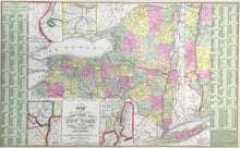
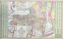
S. Augustus Mitchell (1790-1868). Plate 10. “Map of The State Of New York Compiled From The Latest Authorities.” From A New Universal Atlas…
Philadelphia: Cowperthwait, Desilver & Butler, 1854. Double folio. 16 1/8 x 26 1/4. Lithographic transfer from engraved plate. Full original hand coloring. Very good condition.
With five inset maps (Vicinity of Falls of Niagara, Vicinity of Rochester, Vicinity of Albany, Vicinity of New York, and Map of Hudson River from New York to Albany), this highly detailed map of the Empire State is a fine example of S. Augustus Mitchell's map of New York State. The fact that this is one of only two double-page maps in the New Universal Atlas testifies to the importance of New York in the mid-19th century.
Covering the entire state from Lake Erie to the Connecticut/Vermont borders and from Canada to New York City, the map is hand colored by counties and shows towns, roads, railroads, rivers, canals, steamship routes, etc. To the left and right of the map proper, county and township population data from the 1850 Census is provided. The table also shows the area of each county in square miles, and has a fascinating compilation of “Miscellaneous Statistics” that includes white/black population, imports/exports, crop yields, schools and colleges and the like. This colorful and information-filled map is one of the most highly sought after mid-19th Century maps of New York State to appear in a commercial atlas.


