

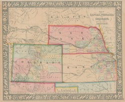
S. Augustus Mitchell, Jr. “Map of Kansas, Nebraska and Colorado Showing also The Southern portion of Dacotah”.
Philadelphia: S. Augustus Mitchell, Jr., 1866. 11 1/2 x 14. Lithograph. Full original color. Decorative border. Very good condition.
This fine of the plains states if from a post war issue of S. Augustus Mitchell Jr.’s important atlas. The map shows the territories of Kansas and Nebraska shortly after they were reorganized into their present borders (though they were still territories for a number of years yet). Their reorganization was started by the creation of the territory of Colorado in 1861 as a result of the Pikes Peak Gold Rush. The area of this rush is shown as the “Gold Region,” and the towns of Denver City and Auraria (the two which would joined together to form Denver), as well as Boulder, Golden, Central City, Breckinridge, all of which are shown on this map.
Colorado was created to a great extent from the western part of Kansas, which thus was shrunk to its current size. Nebraska also lost some land to Colorado in 1861, but it was mostly reduced by the organization of the lands north of 43° N becoming the Dakota Territory. In 1863, the western part of both Dakota and Nebraska were subsumed in the new territory of Idaho, but the following year the northeastern part of Idaho became Montana and the southeastern part, shown in the upper left of this map, was “Attached to Dacotah.” This was a period of the planning of the trans-continental railroad and Mitchell shows a number of the considered routes with dashed lines. This map was issued at a time when this region was flooded by settlers, miners and emigrants seeking new opportunities in the burgeoning American West. The eastern-most parts of Kansas and Nebraska are shown fairly well settled, and in the west are shown a few new settlements, forts, and Indian tribes. With updated maps in most atlases, Mitchell pictured this fascinating part of American history at a transitional stage.
 %20%0A%20%0Ahttps://philaprintshop.com/products/mitchell-s-augustus-jr-map-of-kansas-nebraska-and-colorado-showing-also-the-southern-portion-of-dacotah %20%0A%20%0AMitchell,%20S.%20Augustus%20Jr.%20%20%E2%80%9CMap%20of%20Kansas,%20Nebraska%20and%20Colorado%20Showing%20also%20The%20Southern%20portion%20of%20Dacotah%E2%80%9D %20%0A%20%0A//philaprintshop.com/cdn/shop/products/mitch66ksnbcodk_1024x1024.jpg?v=1627586061 %20%0A%20%0AAntique Prints, Maps, Drawings, Paintings and Rare Books! %20%0A%20%0AThe Philadelphia Print Shop %20%0A106 E. Lancaster Avenue, Lower Level %20%0AWayne, PA 19087 %20%0A%20%0APhilaPrintShop.com %20%0A@PhiladelphiaPrintShop %20%0A 610 (808) 6165)