


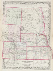
S. Augustus Mitchell Jr. “County Map of Kansas, Nebraska, Colorado, Dakota, Wyoming, Montana.”
Philadelphia: S. Augustus Mitchell, Jr., 1872. 20 x 15. Lithograph. Original hand color. Very good condition.
For much of the middle part of the nineteenth century, the firm founded by S. Augustus Mitchell dominated American cartography in output and influence. This fine map is from one of his son’s atlases issued second half of the century. This map shows the northern plains at a time when the railroads were opening up the region to new settlement. Completed in 1869, the transcontinental railroad ran across the center of the area shown here, from Omaha to the South Pass in western Wyoming, while the Northern Pacific, begun just three years before, had made it partway across the Dakota Territory. The railroads facilitated the movement of emigrants through and into this area—already begun by the emigration to Oregon, the California Gold Rush and Pike’s Peak Gold Rush (noted on this map as “Gold Region”). This led to the creation of new states, such as Kansas (1861), Nebraska (1867), as well as territories such as Colorado, Dakota, Montana, and the recently created Wyoming (1869).
This detailed map provides a good topographical picture of the region, with the rivers and mountains depicted, as are the locations of the plains Indian tribes which played such an important (and tragic) role in the opening of the west. The maps also well represents the development of this region, picturing towns, forts, roads and trails. Of particular interest is the depiction of the railroads, for Mitchell updated his map of this region showing newly built tracks. These include the Northern Pacific across Dakota as well as railroads running out of Denver to the south and into the mountains to the west. This is a fine map of the classic “Wild West” of popular lore.
 %20%0A%20%0Ahttps://philaprintshop.com/products/mitchell-s-augustus-county-map-of-kansas-nebraska-colorado-dakota-wyoming-montana %20%0A%20%0AMitchell,%20S.%20Augustus%20%20%E2%80%9CCounty%20Map%20of%20Kansas,%20Nebraska,%20Colorado,%20Dakota,%20Wyoming,%20Montana%E2%80%9D %20%0A%20%0A//philaprintshop.com/cdn/shop/files/mitchellksnbco1872c_1024x1024.jpg?v=1686155946 %20%0A%20%0AAntique Prints, Maps, Drawings, Paintings and Rare Books! %20%0A%20%0AThe Philadelphia Print Shop %20%0A106 E. Lancaster Avenue, Lower Level %20%0AWayne, PA 19087 %20%0A%20%0APhilaPrintShop.com %20%0A@PhiladelphiaPrintShop %20%0A 610 (808) 6165)