


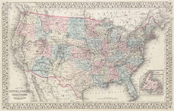
S.A. Mitchell Jr. "Map of The United States, and Territories. Together With Canada &c." From A New General Atlas.
Philadelphia: S.A. Mitchell, Jr. 1880. Lithograph. Original hand color. 13 ¼ x 21 ¼. With decorative grape vine border. Very good condition.
All western territories are shown with their present day state borders with the exception of the the Dakotah and Indian Territories. Yellowstone Park is shown in the upper left hand corner of Wyoming which was created in 1872.
 %20%0A%20%0Ahttps://philaprintshop.com/products/mitchell-jr-s-a-map-of-the-united-states-and-territories-together-with-canada-c-1880 %20%0A%20%0AMitchell%20Jr.,%20S.A.%20%22Map%20of%20The%20United%20States,%20and%20Territories.%20Together%20With%20Canada%20%26c.%22%201880 %20%0A%20%0A//philaprintshop.com/cdn/shop/products/mitchellus1880c_1024x1024.jpg?v=1652893229 %20%0A%20%0AAntique Prints, Maps, Drawings, Paintings and Rare Books! %20%0A%20%0AThe Philadelphia Print Shop %20%0A106 E. Lancaster Avenue, Lower Level %20%0AWayne, PA 19087 %20%0A%20%0APhilaPrintShop.com %20%0A@PhiladelphiaPrintShop %20%0A 610 (808) 6165)