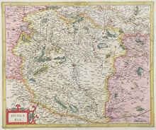
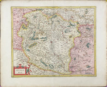
Gerard Mercator. “Hungaria.” From the Mercator-Hondius Atlas.
Amsterdam: Jodocus Hondius, 1613. 14 3/8 x 17 ¼. Engraving. Full original color. Full margins. Very good condition. Latin text on verso.
Gerard Mercator (1512-1594) ranks as one of the greatest cartographers in history, not only for the extremely fine maps he produced, but also for the innovations which he introduced into cartographic science. Until the end of the sixteenth century, Ptolemy’s concept of depicting sections of the world in trapezoidal configurations, like gores from a globe, had predominated. Mercator, however, stated that small sections of the earth were not significantly distorted toward the poles if longitude lines were represented as parallel by squares or rectangles. The development of the “Mercator projection,” which became the established convention, was particularly important for the improvements it allowed in navigational methods.
Through his constant accumulation of new geographic and cosmological data, Mercator was able to produce the most accurate and current maps of his day, which unlike most of his contemporaries’ maps were mostly original work. His maps not only are excellent cartographically, but they are aesthetically superb as well, with beautiful cartouches, silken seas and other exquisite ornamentation. Mercator intended to produce a complete description of creation, heaven, the earth and the seas, a project he was only beginning when he died. Such was his influence that the title he chose for this projected work, “Atlas,” has now become the generic name for all collections of maps.
Jodocus Hondius (1563-1611), who shared a vision similar to Mercator’s, took up Mercator’s ambitious project after the latter’s death, purchasing Mercator’s plates in 1604 and publishing a series of editions of the Mercator-Hondius Atlas, beginning in 1606. This series of constantly updated atlases reflected Hondius’ continued pursuit of geographical knowledge and craftsmanship in order to produce a superior work. The maps from this particular Mercator-Hondius Atlas are especially excellent.


