

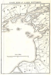
John Melish. “East End of Lake Ontario.” From A Military and Topographical Atlas of the United States.
Philadelphia: J. Melish, March 1813. 5/8 x 4 1/2. Engraving by H.S. Tanner.
A small map of the eastern end of Lake Ontario by one of the seminal figures in the history of American cartography. John Melish was the first American publisher to issue exclusively cartographic and geographic items. Born in Scotland and involved in the textile industry, Melish visited the United States several times beginning in 1806, finally deciding to settle there in 1811. Melish had made many notes on his travels about the country and in 1812 he published Travels in the United States of America, which included his first maps and which started him on his cartographic career. A year later he issued an atlas related to the War of 1812, from which this map comes. Melish came to dominate the industry in this country, and had a huge impact on all subsequent American mapping. This map was also sold separately, as stated in an advertisement in Melish’s 1819 Traveller’s Directory, “Octavo Maps of Philadelphia, New York, Baltimore, Boston, Pittsburg, Zanesville, Falls of Niagara, Falls of Ohio, East End of Lake Ontario and Montreal–12 1/2 cents, each.”
 %20%0A%20%0Ahttps://philaprintshop.com/products/melish-john-east-end-of-lake-ontario %20%0A%20%0AMelish,%20John%20%22East%20End%20of%20Lake%20Ontario%E2%80%9D %20%0A%20%0A//philaprintshop.com/cdn/shop/files/melishontario_1024x1024.jpg?v=1715115385 %20%0A%20%0AAntique Prints, Maps, Drawings, Paintings and Rare Books! %20%0A%20%0AThe Philadelphia Print Shop %20%0A106 E. Lancaster Avenue, Lower Level %20%0AWayne, PA 19087 %20%0A%20%0APhilaPrintShop.com %20%0A@PhiladelphiaPrintShop %20%0A 610 (808) 6165)