


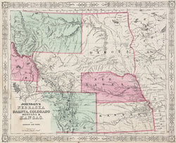
A.J. Johnson. "Johnson's Nebraska, Dakota, Colorado, Montana & Kansas."
New York: Johnson & Ward, 1865. 12 1/2 x 15 1/2. Lithograph. Original hand coloring. Water stain bottom left hand side. Repaired tears in stain. Else, good condition.
A detailed map of northern plains states (present-day Kansas, Nebraska, Colorado, the Dakotas, Wyoming, eastern Idaho and Montana). This map shows an interesting configuration of the region, ca. 1864. By 1861 the state of Kansas and the Nebraska Territory had been reorganized into their present configurations. In 1863, the huge Dakota Territory had its western part attached to the new Idaho Territory, comprising today's Idaho, Montana and Wyoming. The next year, the northeastern part of this was created as the Montana Territory and the southeastern part was reattached to Dakota, creating a rather unusual shape for that territory. Such is the political situation shown on this map. The detail is most impressive, showing rivers, towns, forts, Indian tribes, and the early trails which criss-crossed this region. This map, issued at the end of the Civil War, shows these territories just before they were filled with new settlers, miners and other speculators. This is a wonderful map of an important period in the history of the region.
 %20%0A%20%0Ahttps://philaprintshop.com/products/johnson-a-j-johnsons-nebraska-dakota-colorado-montana-kansas %20%0A%20%0AJohnson,%20A.J.%20%22Johnson's%20Nebraska,%20Dakota,%20Colorado,%20Montana%20%26%20Kansas%22 %20%0A%20%0A//philaprintshop.com/cdn/shop/files/johnsonnbdakco1865c_1024x1024.jpg?v=1686159052 %20%0A%20%0AAntique Prints, Maps, Drawings, Paintings and Rare Books! %20%0A%20%0AThe Philadelphia Print Shop %20%0A106 E. Lancaster Avenue, Lower Level %20%0AWayne, PA 19087 %20%0A%20%0APhilaPrintShop.com %20%0A@PhiladelphiaPrintShop %20%0A 610 (808) 6165)