


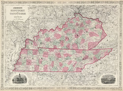
A.J. Johnson. "Johnson's Kentucky and Tennessee."
New York: Johnson & Ward, 1864. 17 1/2 x 24 1/4. Lithograph. Full original hand-color. Two vignettes. Strap work border. Two old repaired tears into borders. Very good condition.
An attractive map from A. J. Johnson's atlas issued during the Civil War. Johnson, who published out of New York City, was one of the leading cartographic publishers in the latter half of the century, producing popular atlases, geographies and so on. This finely detailed map is a good example of Johnson's work. Townships, towns, roads, rail lines, rivers and lakes are shown throughout. Of particular note is the extensive road and rail networks in the states that were so important in the ongoing conflict. The clear presentation of cartographic information and the warm hand coloring make this an attractive as well as interesting historical document. It is an excellent example of Johnson's, and thus American, cartography.
 %20%0A%20%0Ahttps://philaprintshop.com/products/johnson-a-j-johnsons-kentucky-and-tennessee-1864 %20%0A%20%0AJohnson,%20A.J.%20%22Johnson's%20Kentucky%20and%20Tennessee%22%201864 %20%0A%20%0A//philaprintshop.com/cdn/shop/files/johnsonkytn1862c_1024x1024.jpg?v=1749234507 %20%0A%20%0AAntique Prints, Maps, Drawings, Paintings and Rare Books! %20%0A%20%0AThe Philadelphia Print Shop %20%0A106 E. Lancaster Avenue, Lower Level %20%0AWayne, PA 19087 %20%0A%20%0APhilaPrintShop.com %20%0A@PhiladelphiaPrintShop %20%0A 610 (808) 6165)