


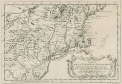
Jacques N. Bellin. "Carte de la Nouvelle Angleterre, Nouvelle Yorck, et Pensilvanie"
Engraving. Paris: J.N. Bellin, 1757. 8 x 11 1/2 (neat lines) plus full margins. Very good condition. McCorkle, 757.1.
A well drawn map of the American northeast by Jacques Nicolas Bellin, the Hydrographer to the King of France. From about 1650 to 1750, the French dominated the cartographic world, with their fine, scientifically based maps, elegantly engraved and precisely detailed. Bellin (1703-72) was one of the best in the later period. This map shows the region from Delaware Bay to present-day Maine at the beginning of the French & Indian War. Topography is well presented, with rivers, lakes, and settlements clearly drawn. Of particular note are the indications of the forts that would play such an important role during the war, including Forts Niagara and Owego on Lake Erie, and in the strategic region between the Hudson and Lake Champlain, Forts George, Carillon, Edward, Lyduis, Anne, and Nicolson. Also of interest is the nascent road system. A major road runs along most of the coast, and several branches go inland, including one that lead to York in Pennsylvania and one that goes up the Hudson River to Albany and then up the Mohawk River.
 %20%0A%20%0Ahttps://philaprintshop.com/products/jacques-n-bellin-carte-de-la-nouvelle-angleterre-nouvelle-yorck-et-pensilvanie %20%0A%20%0ABellin,%20Jacques%20N.%20%20%22Carte%20de%20la%20Nouvelle%20Angleterre,%20Nouvelle%20Yorck,%20et%20Pensilvanie%22 %20%0A%20%0A//philaprintshop.com/cdn/shop/files/bellinewenglandc_1024x1024.jpg?v=1752248262 %20%0A%20%0AAntique Prints, Maps, Drawings, Paintings and Rare Books! %20%0A%20%0AThe Philadelphia Print Shop %20%0A106 E. Lancaster Avenue, Lower Level %20%0AWayne, PA 19087 %20%0A%20%0APhilaPrintShop.com %20%0A@PhiladelphiaPrintShop %20%0A 610 (808) 6165)