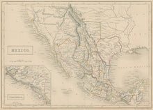
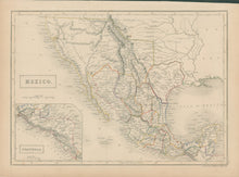
Sidney Hall. “Mexico.” Inset in lower left of “Guatimala.”
Edinburgh: A. & C. Black, 1840. 10 x 14 5/8. Engraving. Original outline color. Very good condition. Phillips Atlases: 777.
A fascinating map of Mexico and the American southwest issued in Edinburgh in 1840. Topography, coastal information, and settlements are shown throughout, with particularly good detail given for Mexico and Texas. Of particular interest is the fact that Texas is shown as a republic. Texas had declared its independence just a few years before this map was issued, and Sidney Hall tried to show the new situation with as good information as he had. The old Mexican internal borders are shown, but Texas is named and is indicated as extending well to the northwest, up towards Santa Fe as claimed by the Texans. The Great Salt Lake is shown, named as “L. Youta or Salt Lake,” and on its eastern shore is indicated “American Fur Co.’s Depot.” Throughout the region are indications of Indian tribes. Of special interest are the markings of roads and major trade routes, including the great road from Chihuahua north to Santa Fe and the “Gr’t Spanish Road” from Natchez west along the Red River to Santa Fe. Overall, this is a fascinating and very up-to-date mapping of this region at an important period in its history.


