
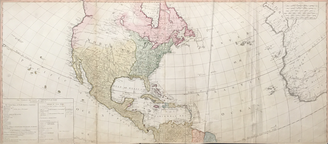
John Gibson. [A New Map of the Whole Continent of America . . .]
London: Laurie & Whittle, 1794. 20 3/8 x 46 3/4. Engraving. Original hand color. Top two sheets (joined) of four. Several old vertical folds. Numerous short tears in map from map extremities newly repaired with archival tape along with previous old repairs. Small ink smear in Bay of Panama. Else, fine condition.
The top top half of a wonderful, large four sheet map of the American continent from northern Canada down to the southern tip of South America, including the West Indies, and the western tip of Africa and Europe. This map was originally drawn by John Gibson in 1763, and it was a modified version of D'Anville's map of North & South America, and it was later updated using the cartographic information of Governor Thomas Pownall, who was one of America's important early cartographers.
The version updated with Thomas Pownall's information was first issued in 1777 by Sayer & Bennett, using information from Pownall's important maps of the preceding three decades, including his important reissue of Lewis Evans map of the Middle Colonies with his own addendum showing New England. This is a further updated issue by Laurie & Whittle later in the century. The detail depicted is impressive, including rivers, lakes, towns, Indian settlements, mountains, roads, and many other such features. Also included is a table listing the United States and the possessions of the various European powers.
 %20%0A%20%0Ahttps://philaprintshop.com/products/gibson-john-a-new-map-of-the-whole-continent-of-america %20%0A%20%0AGibson,%20John%20%20%22A%20New%20Map%20of%20the%20Whole%20Continent%20of%20America%20.%20.%20.%22 %20%0A%20%0A//philaprintshop.com/cdn/shop/products/ScreenShot2021-03-09at12.22.35AM_1024x1024.png?v=1615271159 %20%0A%20%0AAntique Prints, Maps, Drawings, Paintings and Rare Books! %20%0A%20%0AThe Philadelphia Print Shop %20%0A106 E. Lancaster Avenue, Lower Level %20%0AWayne, PA 19087 %20%0A%20%0APhilaPrintShop.com %20%0A@PhiladelphiaPrintShop %20%0A 610 (808) 6165)