

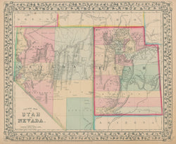
W.H. Gamble. "County Map of Utah and Nevada".
Philadelphia: S. Augustus Mitchell Jr., 1867. 11 1/4 x 13 3/4. Lithographed by W. H. Gamble. Hand color. Very good condition.
For most of the middle part of the nineteenth century, the firm founded by S. Augustus Mitchell, Sr. dominated American cartography in output and influence. This fine map is from one of his son's atlases, and it shows the territory of Utah and the state of Nevada in the final year of the Civil War. Towns, rivers, roads and other topographical information are clearly shown, and the counties are shaded with contrasting pastel colors. When Nevada became a state in 1864, the border of Utah and Nevada was moved east from the 115th to the 114th meridian. This map shows Nevada's correct eastern boundary at the 114th meridian, though a year or two earlier, Mitchell’s maps still showed the former border. Note also that Nevada extends south only to the 37 degree latitude. An interesting early rendering of the region.
 %20%0A%20%0Ahttps://philaprintshop.com/products/gamble-w-h-county-map-of-utah-and-nevada %20%0A%20%0AGamble,%20W.H.%20%20%22County%20Map%20of%20Utah%20and%20Nevada%22 %20%0A%20%0A//philaprintshop.com/cdn/shop/products/mitch65nvut_1024x1024.jpg?v=1627586453 %20%0A%20%0AAntique Prints, Maps, Drawings, Paintings and Rare Books! %20%0A%20%0AThe Philadelphia Print Shop %20%0A106 E. Lancaster Avenue, Lower Level %20%0AWayne, PA 19087 %20%0A%20%0APhilaPrintShop.com %20%0A@PhiladelphiaPrintShop %20%0A 610 (808) 6165)