


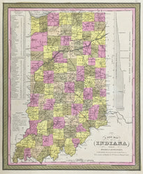
S. Augustus Mitchell. "A New Map of Indiana with its Roads & Distances." From A New Universal Atlas.
Philadelphia: S. Augustus Mitchell, 1848. 14 x 11 1/2. Lithograph transfer from engraved plate. Original hand-coloring. Very good condition.
An fine map of Indiana by S. Augustus Mitchell Sr. For much of the middle part of the nineteenth century, the Mitchell firm dominated American cartography in output and influence. S. Augustus Mitchell Jr.'s maps of the 1860s are probably the best known issues of this firm, but his father's earlier efforts are excellent maps derived from H.S. Tanner's atlas of the 1830s. This early map of Indiana is a good example of this work and was one of the best maps of the state issued to that time. Of particular note on this map is the indication of the transportation network–roads, canals and railroads–throughout the state. Included at the right side is a profile of the Wabash and Erie Canal and on the left is a list of the stops and distances on the steam board routes in the state. A superior map of the state just prior to mid-century.
 %20%0A%20%0Ahttps://philaprintshop.com/products/copy-of-mitchell-s-augustus-a-new-map-of-the-state-of-iowa %20%0A%20%0AMitchell,%20S.%20Augustus%20%20%E2%80%9CA%20New%20Map%20of%20Indiana%20with%20its%20Roads%20%26%20Distances.%22 %20%0A%20%0A//philaprintshop.com/cdn/shop/products/mitchellin1848c_1024x1024.jpg?v=1639518388 %20%0A%20%0AAntique Prints, Maps, Drawings, Paintings and Rare Books! %20%0A%20%0AThe Philadelphia Print Shop %20%0A106 E. Lancaster Avenue, Lower Level %20%0AWayne, PA 19087 %20%0A%20%0APhilaPrintShop.com %20%0A@PhiladelphiaPrintShop %20%0A 610 (808) 6165)