


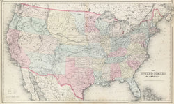
“The United States of America.”
New York: J.H. Colton, [1856]-ca. 1858. 14 5/8 x 25. Lithograph. Original hand color. Very good condition.
A fine, detailed map of the United States showing the nation’s political configuration just after the Compromise of 1850 and the Kansas-Nebraska act of 1854. The former act established California as a state and set up the Utah and New Mexico territories between the new state and the Rocky mountains. The latter act broke up the old Missouri Territory and Indian Territories to create the Kansas Territory, running from Missouri to the Utah Territory, and the Nebraska Territory from Kansas to the Canadian border. The Colton firm kept their maps very up-to-date, so this map shows this situation clearly and with good detail. Besides the usual rivers, settlements, forts and such, this map also shows both the “Oregon Route” and the “Santa Fe Route,” as well as the proposed routes for the planned trans-continental railroad. This map has a copyright date of 1855, but shows the newly formed state of Minnesota and territory of Dakotah (1858).
 %20%0A%20%0Ahttps://philaprintshop.com/products/colton-the-united-states-of-america-1858 %20%0A%20%0AColton%20%E2%80%9CThe%20United%20States%20of%20America%22%201858 %20%0A%20%0A//philaprintshop.com/cdn/shop/products/coltonus1858c_1024x1024.jpg?v=1652896738 %20%0A%20%0AAntique Prints, Maps, Drawings, Paintings and Rare Books! %20%0A%20%0AThe Philadelphia Print Shop %20%0A106 E. Lancaster Avenue, Lower Level %20%0AWayne, PA 19087 %20%0A%20%0APhilaPrintShop.com %20%0A@PhiladelphiaPrintShop %20%0A 610 (808) 6165)