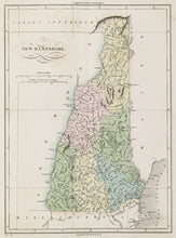
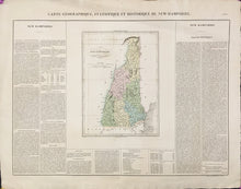
Jean Alexandre C. Buchon after Carey & Lea. "Carte Géographique, Statistique et Historique De New Hampshire."
Paris: J. Carez, 1825. 11 1/2 x 8 1/2 (map); 17 3/8 x 24 (full sheet). Engraving by B. de Beaupre. Original hand color. Full margins. Excellent condition.
In 1822, Carey & Lea issued their important American Atlas, containing maps each of which were accompanied by an historical and statistical account of the area depicted. Three years later Jean Buchon issued his revised, French edition of the atlas, Atlas Geographique des deux Amériques. Following the earlier format with maps surrounded by the text, Buchon's maps are fascinating Franco-American documents, presenting a comprehensive statement of the French understanding of what was still considered the 'New World.' The maps have excellent detail, and the text is filled with information on the climate, economy, topography, government, and so forth. One of the earliest maps of the state of New Hampshire published outside of America, the surrounding text contains contemporary details of topography, climate, rivers, towns, population by county, plus commercial and other information.


