![Blaeu, Willem “Descriptio Veromanduorum…Gallice Vermandois” with “Gouvernement de la Cappelle” [Vermandois & Cappelle, France]](http://philaprintshop.com/cdn/shop/files/blaeufrance15thmb_{width}x.jpg?v=1718465959)
![Blaeu, Willem “Descriptio Veromanduorum…Gallice Vermandois” with “Gouvernement de la Cappelle” [Vermandois & Cappelle, France]](http://philaprintshop.com/cdn/shop/files/blaeufrance15_{width}x.jpg?v=1718465969)
![Blaeu, Willem “Descriptio Veromanduorum…Gallice Vermandois” with “Gouvernement de la Cappelle” [Vermandois & Cappelle, France]](http://philaprintshop.com/cdn/shop/files/blaeufrance15thmb_530x@2x.jpg?v=1718465959)
![Load image into Gallery viewer, Blaeu, Willem “Descriptio Veromanduorum…Gallice Vermandois” with “Gouvernement de la Cappelle” [Vermandois & Cappelle, France]](http://philaprintshop.com/cdn/shop/files/blaeufrance15thmb_1024x1024@2x.jpg?v=1718465959)
![Load image into Gallery viewer, Blaeu, Willem “Descriptio Veromanduorum…Gallice Vermandois” with “Gouvernement de la Cappelle” [Vermandois & Cappelle, France]](http://philaprintshop.com/cdn/shop/files/blaeufrance15_1024x1024@2x.jpg?v=1718465969)
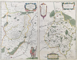
Willem Blaeu. “Descriptio Veromanduorum…Gallice Vermandois” with “Gouvernement de la Cappelle.” [Vermandois & Cappelle, France].
From Nouvel Atlas. Amsterdam: Willem & Joan Blaeu, 1643-50. Double folio map, ca. 15 x 21. Engraving. Excellent original hand color. French text on verso. Light staining in bottom margin and into map right hand side.
A series of wonderfully decorative maps of France, Spain, the Netherlands and their regions by Willem (Guilielmus) Janszoon Blaeu (1571-1638), the progenitor of the famous Blaeu cartographic firm of Amsterdam. Blaeu studied astronomy and sciences with Tycho Brahe, and in 1599 established a globe and instrument making business which soon expanded to include cartographic and geographic publishing. This firm was to go on to become the largest and most important cartographic publishing firms in the world, run by his sons Cornelis (until his death in 1642) and Joan. The maps issued by the Blaeu firm are known for their fine craftsmanship and design, and have been called “the highest expression of Dutch cartographical art.” These maps, with their excellent original color, are premier examples of the Blaeu output.
 %20%0A%20%0Ahttps://philaprintshop.com/products/blaeu-willem-descriptio-veromanduorum-gallice-vermandois-with-gouvernement-de-la-cappelle-vermandois-cappelle-france %20%0A%20%0ABlaeu,%20Willem%20%20%20%E2%80%9CDescriptio%20Veromanduorum%E2%80%A6Gallice%20Vermandois%E2%80%9D%20with%20%E2%80%9CGouvernement%20de%20la%20Cappelle%E2%80%9D%20%20[Vermandois%20%26%20Cappelle,%20France] %20%0A%20%0A//philaprintshop.com/cdn/shop/files/blaeufrance15thmb_1024x1024.jpg?v=1718465959 %20%0A%20%0AAntique Prints, Maps, Drawings, Paintings and Rare Books! %20%0A%20%0AThe Philadelphia Print Shop %20%0A106 E. Lancaster Avenue, Lower Level %20%0AWayne, PA 19087 %20%0A%20%0APhilaPrintShop.com %20%0A@PhiladelphiaPrintShop %20%0A 610 (808) 6165)