![Blaeu, Joan “Insula Sacra; Vulgo Holy Iland [sic]; et Farne.” [Lindisfarne and the Farne Islands, Northumberland]](http://philaprintshop.com/cdn/shop/products/blaeu-lindesfarnec_{width}x.jpg?v=1677705999)
![Blaeu, Joan “Insula Sacra; Vulgo Holy Iland [sic]; et Farne.” [Lindisfarne and the Farne Islands, Northumberland]](http://philaprintshop.com/cdn/shop/products/blaeu-lindesfarne_{width}x.jpg?v=1677706004)
![Blaeu, Joan “Insula Sacra; Vulgo Holy Iland [sic]; et Farne.” [Lindisfarne and the Farne Islands, Northumberland]](http://philaprintshop.com/cdn/shop/products/blaeu-lindesfarnec_530x@2x.jpg?v=1677705999)
![Load image into Gallery viewer, Blaeu, Joan “Insula Sacra; Vulgo Holy Iland [sic]; et Farne.” [Lindisfarne and the Farne Islands, Northumberland]](http://philaprintshop.com/cdn/shop/products/blaeu-lindesfarnec_1024x1024@2x.jpg?v=1677705999)
![Load image into Gallery viewer, Blaeu, Joan “Insula Sacra; Vulgo Holy Iland [sic]; et Farne.” [Lindisfarne and the Farne Islands, Northumberland]](http://philaprintshop.com/cdn/shop/products/blaeu-lindesfarne_1024x1024@2x.jpg?v=1677706004)
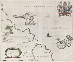
Joan Blaeu (1596-1673). “Insula Sacra; Vulgo Holy Iland [sic]; et Farne.” [Lindisfarne and the Farne Islands, Northumberland]. From Nouvel Atlas.
Amsterdam: Joan Blaeu, 1643-50. 16 ½ x 20 ½ (neat lines). Engraving. Original hand color. Very good condition. An elegant map by Johannes Blaeu. Johannes was the son of William Blaeu, the progenitor of the famous Blaeu cartographic firm of Amsterdam. Blaeu, Sr. studied astronomy and sciences with Tycho Brahe, and in 1599 established a globe and instrument making business which soon expanded to include cartographic and geographic publishing. This firm was to go on to become the largest and most important cartographic publishing firms in the world, later run by his sons Cornelis (until his death in 1642) and Johannes. The maps issued by the Blaeu firm are known for their fine engraving, coloring and design, and have been called “the highest expression of Dutch cartographical art.” The atlas of maps of Britain issued by the firm is known for containing some of the most attractive and elegant maps of the counties ever issued.
 %20%0A%20%0Ahttps://philaprintshop.com/products/blaeu-joan-insula-sacra-vulgo-holy-iland-sic-et-farne-lindisfarne-and-the-farne-islands-northumberland %20%0A%20%0ABlaeu,%20Joan%20%E2%80%9CInsula%20Sacra;%20Vulgo%20Holy%20Iland%20[sic];%20et%20Farne.%E2%80%9D%20%20[Lindisfarne%20and%20the%20Farne%20Islands,%20Northumberland] %20%0A%20%0A//philaprintshop.com/cdn/shop/products/blaeu-lindesfarnec_1024x1024.jpg?v=1677705999 %20%0A%20%0AAntique Prints, Maps, Drawings, Paintings and Rare Books! %20%0A%20%0AThe Philadelphia Print Shop %20%0A106 E. Lancaster Avenue, Lower Level %20%0AWayne, PA 19087 %20%0A%20%0APhilaPrintShop.com %20%0A@PhiladelphiaPrintShop %20%0A 610 (808) 6165)