![Bertius, Pieter “Veromãdui.” [Beaurevoir area, France]](http://philaprintshop.com/cdn/shop/products/bertius-veromaduic_{width}x.jpg?v=1678908205)
![Bertius, Pieter “Veromãdui.” [Beaurevoir area, France]](http://philaprintshop.com/cdn/shop/products/bertius-veromadui_{width}x.jpg?v=1678908210)
![Bertius, Pieter “Veromãdui.” [Beaurevoir area, France]](http://philaprintshop.com/cdn/shop/products/bertius-veromaduic_530x@2x.jpg?v=1678908205)
![Load image into Gallery viewer, Bertius, Pieter “Veromãdui.” [Beaurevoir area, France]](http://philaprintshop.com/cdn/shop/products/bertius-veromaduic_1024x1024@2x.jpg?v=1678908205)
![Load image into Gallery viewer, Bertius, Pieter “Veromãdui.” [Beaurevoir area, France]](http://philaprintshop.com/cdn/shop/products/bertius-veromadui_1024x1024@2x.jpg?v=1678908210)
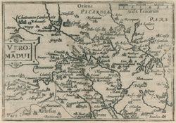
Pieter Bertius (1565-1629). “Veromãdui.” [Beaurevoir area, France]. Tabularum Geographicarum Contractarum.
Amsterdam: Cornelis Claesz, 1606. Engravings by J. Hondius and Pieter van den Keere. Approx. 3 1/2 x 5. Latin text on verso.
An early seventeenth century map issued in a popular geography written by Pieter Bertius. These maps were engraved by the brother-in-laws, Jodocus Hondius and Pieter van den Keere. The maps have a charm which comes from their fine engraving and small size, and they present some of the most up-to-date information of areas around the world available at the time.
 %20%0A%20%0Ahttps://philaprintshop.com/products/bertius-pieter-veromadui-beaurevoir-area-france %20%0A%20%0ABertius,%20Pieter%20%20%E2%80%9CVerom%C3%A3dui.%E2%80%9D%20[Beaurevoir%20area,%20France] %20%0A%20%0A//philaprintshop.com/cdn/shop/products/bertius-veromaduic_1024x1024.jpg?v=1678908205 %20%0A%20%0AAntique Prints, Maps, Drawings, Paintings and Rare Books! %20%0A%20%0AThe Philadelphia Print Shop %20%0A106 E. Lancaster Avenue, Lower Level %20%0AWayne, PA 19087 %20%0A%20%0APhilaPrintShop.com %20%0A@PhiladelphiaPrintShop %20%0A 610 (808) 6165)