


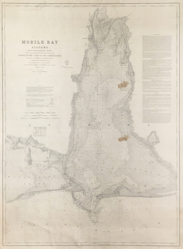
A.D. Bache. “Mobile Bay Alabama.”
Washington: U.S. Coastal Survey, 1856. Separately issued U.S. coastal chart. 38 x 28 1/8. Engraving by S. Siebert, F. Dankworth, J. Knight, J.H. Goldthwaite, J.N.N. Throop, & H.M. Knight. Two stains in map and a few repaired tears in margin. Chip in margin top left hand side filled with old paper. Else, very good condition.
A highly detailed chart showing Mobile Bay, a fine example of the output of the U.S. Coast Survey. The single-minded purpose of Ferdinand Hassler, a Swiss immigrant, is what first brought the Coast Survey into existence. As the first Superintendent of the Coast Survey, 1816-1818 and 1832-1843, he imbued the organization with love of "truth" and unswerving compromise with the twin principles of accuracy and precision. His motto was: "It is the duty of every man to be honest and to do good." Following his death in 1843, Alexander Dallas Bache, a great-grandson of Benjamin Franklin, took over the helm of the Coast Survey. Bache, with his friend Joseph Henry, was dedicated to elevating American science to the front ranks of the world community. As opposed to Hassler who was politically naive, Bache moved smoothly through the American political scene for the benefit of the Coast Survey and American science. The Coast Survey prospered during his tenure as Superintendent and became the first great science organization of the United States Federal Government. Professionally, he became a guiding light of the American Association for the Advancement of Science [presided over three of the first six meetings of the AAAS] and was a founder of the National Academy of Sciences. This chart reflects Hassler and Bache’s dedication and care, and that of all the other superb scientists and craftsmen who worked for the U.S. Coast Survey.
 %20%0A%20%0Ahttps://philaprintshop.com/products/bache-a-d-mobile-bay-alabama %20%0A%20%0ABache,%20A.D.%20%20%E2%80%9CMobile%20Bay%20Alabama.%E2%80%9D %20%0A%20%0A//philaprintshop.com/cdn/shop/products/mobilebayc_1024x1024.jpg?v=1641499638 %20%0A%20%0AAntique Prints, Maps, Drawings, Paintings and Rare Books! %20%0A%20%0AThe Philadelphia Print Shop %20%0A106 E. Lancaster Avenue, Lower Level %20%0AWayne, PA 19087 %20%0A%20%0APhilaPrintShop.com %20%0A@PhiladelphiaPrintShop %20%0A 610 (808) 6165)