

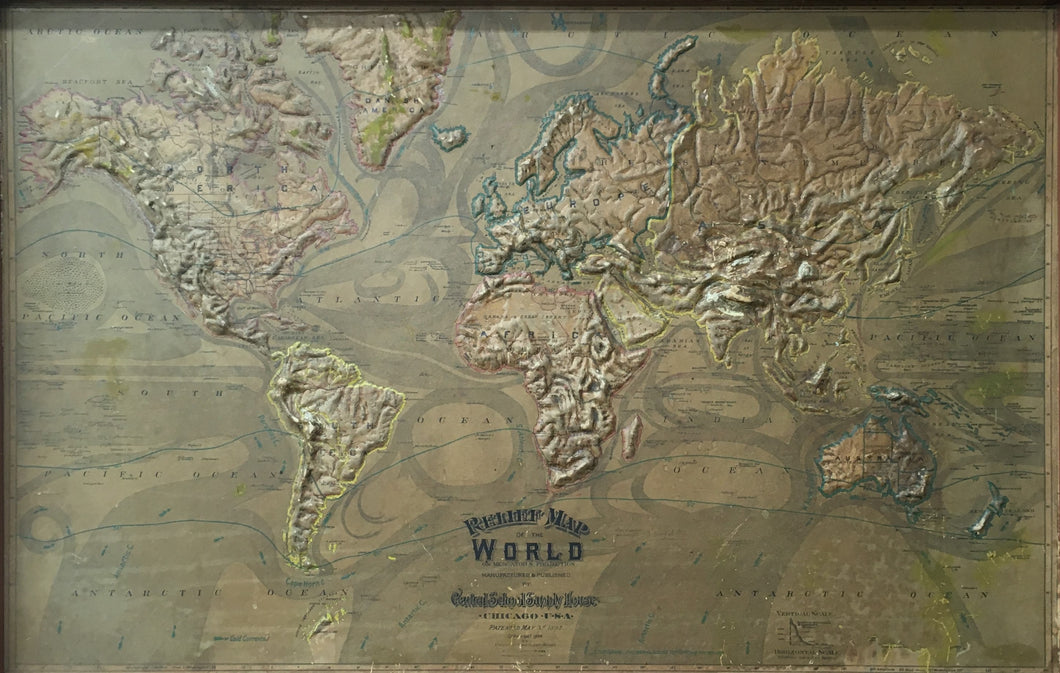


Unattributed. “Relief Map Of The World On Mercator's Projection.”
Chicago: Central School House, [1892]-1899. 26 ½ x 41 ¼ (map). 33 ½ x 48 ¼ frame. Some scrapes and abrasions on map surface as to be expected. New solidly built and painted frame. Good condition.
A 19th century relief map of the world showing by color, raised areas etc., the different heights of land masses. These maps were constructed with layers of cloth, plaster and papier-mâché, molded to show the topography of the continents. These maps in general were a combination of printed and hand coloring. This map offers a combination of political geography, physical topography, and climatology in one raised relief image. Warm and cold water currents are noted with their direction and isotherm lines.
Note: dark horizontal band at top of map is due to shadow from frame.
 %20%0A%20%0Ahttps://philaprintshop.com/products/unattributed-relief-map-of-the-world-on-mercators-projection %20%0A%20%0AUnattributed.%20%20%E2%80%9CRelief%20Map%20Of%20The%20World%20On%20Mercator's%20Projection%E2%80%9D %20%0A%20%0A//philaprintshop.com/cdn/shop/files/worldreliefmapthmb_1024x1024.jpg?v=1695404833 %20%0A%20%0AAntique Prints, Maps, Drawings, Paintings and Rare Books! %20%0A%20%0AThe Philadelphia Print Shop %20%0A106 E. Lancaster Avenue, Lower Level %20%0AWayne, PA 19087 %20%0A%20%0APhilaPrintShop.com %20%0A@PhiladelphiaPrintShop %20%0A 610 (808) 6165)