
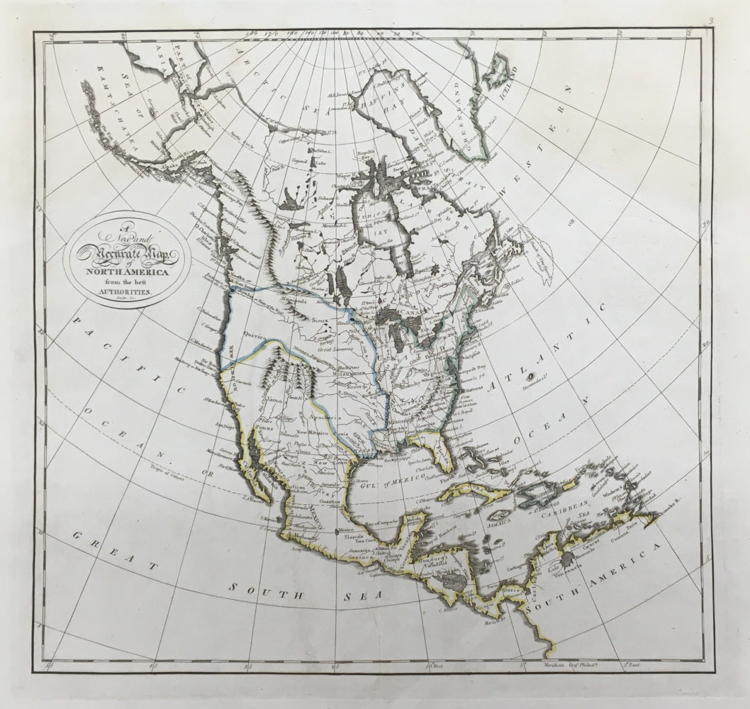
Mathew Carey. "A New and Accurate Map of North America from the Best Authorities."
Philadelphia: M. Carey, 1814. 13 3/8 x 14 1/2. Engraving. Original outline color. Full margins. Very good condition.
An interesting American map of the North America. Published by Mathew Carey in 1814 during the War of 1812, this map is from Carey's Atlas which represented the best American cartographic work of the period. Carey, an Irish immigrant, established the first American specialized cartographic publishing firm. He set up an elaborate cottage system of craftsmen for engraving, printing, and coloring his maps utilizing the best independent artists directed to a common end. Carey is important, then, not only for the excellent maps he produced, but for his setting the pattern for American map publishing, to be followed by the likes of John Melish and Henry S. Tanner.
The map shows the best understanding of the continent prior to the explorations of Lewis & Clark. The map does show the lands of the Louisiana Purchase as belonging to the United States, with the northwestern most part named as "Quivira." The coastline, though, is quite accurate being based on the recent explorations of Vancouver and La Perouse. The river systems in the west are roughly and incorrectly shown, including the "Columbia or River of the West" extending so that it comes very close to some of the branches of the upper Mississippi. Some of the Indian tribes are noted, including Apacheria, Pimas and Yama. The nature of the Rocky Mountains is clearly not known, with the Canadian chain ending above the "River of the West" and there being only a small compact range near the headwaters of the Rio Grande and Colorado Rivers. An excellent map of the period.
 %20%0A%20%0Ahttps://philaprintshop.com/products/mathew-carey-a-new-and-accurate-map-of-north-america-from-the-best-authorities %20%0A%20%0ACarey,%20Mathew%20%22A%20New%20and%20Accurate%20Map%20of%20North%20America%20from%20the%20Best%20Authorities%22 %20%0A%20%0A//philaprintshop.com/cdn/shop/products/carey14namer_1024x1024.jpg?v=1612496091 %20%0A%20%0AAntique Prints, Maps, Drawings, Paintings and Rare Books! %20%0A%20%0AThe Philadelphia Print Shop %20%0A106 E. Lancaster Avenue, Lower Level %20%0AWayne, PA 19087 %20%0A%20%0APhilaPrintShop.com %20%0A@PhiladelphiaPrintShop %20%0A 610 (808) 6165)