

Ensign, Bridgman & Tanning. "Chapin's Ornamental Map of the United States with the New Western Possessions".
New York: Ensign, Bridgman & Tanning, 1851. Separately issued wall map, remounted on new linen. 48 x 60 (full sheet). Engraving with original hand color. Considerable surface cracking and smudging, but expertly conserved and mounted onto new linen. With early wood rollers top and bottom.
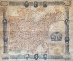
A wonderfully "Ornamental" wall map of the United States from 1856, one in a very popular series of wall maps started by W. Chapin back in 1839. The maps are noted not just for the excellent detail of the United States (with roads, counties, towns, etc. all clearly indicated), but their elaborate architectural motif of columns, graced with four vignettes (of Boston, New York, Philadelphia and Baltimore) and, in this edition, portraits of the first ten American Presidents. The various editions of this map were regularly updated to show new geographic information. Beginning with this edition, new information was added in Minnesota and the surrounding region. A large inset in lower right shows "The Western States and Territories." This inset shows the trans-Mississippi West as it was situated right after the Mexican War (1846-48). California is shown as a state, with Oregon Territory above. The other lands gained from Mexico are shown divided into the New Mexico and Utah Territories (before the Gadsden Purchase). In between those territories and the states and territories on the west side of the Mississippi is a large, unorganized territory label as Nebraska, with a vague Indian Territory to the south. For its excellent, up-to-date information and decorative appeal, this is one of the best mid-19th century maps of the United States.
 %20%0A%20%0Ahttps://philaprintshop.com/products/ensign-bridgman-tanning-chapins-ornamental-map-of-the-united-states-with-the-new-western-possessions %20%0A%20%0AEnsign,%20Bridgman%20%26%20Tanning%20%22Chapin's%20Ornamental%20Map%20of%20the%20United%20States%20with%20the%20New%20Western%20Possessions%22 %20%0A%20%0A//philaprintshop.com/cdn/shop/products/ScreenShot2021-02-15at5.35.19PM_1024x1024.png?v=1613432137 %20%0A%20%0AAntique Prints, Maps, Drawings, Paintings and Rare Books! %20%0A%20%0AThe Philadelphia Print Shop %20%0A106 E. Lancaster Avenue, Lower Level %20%0AWayne, PA 19087 %20%0A%20%0APhilaPrintShop.com %20%0A@PhiladelphiaPrintShop %20%0A 610 (808) 6165)