

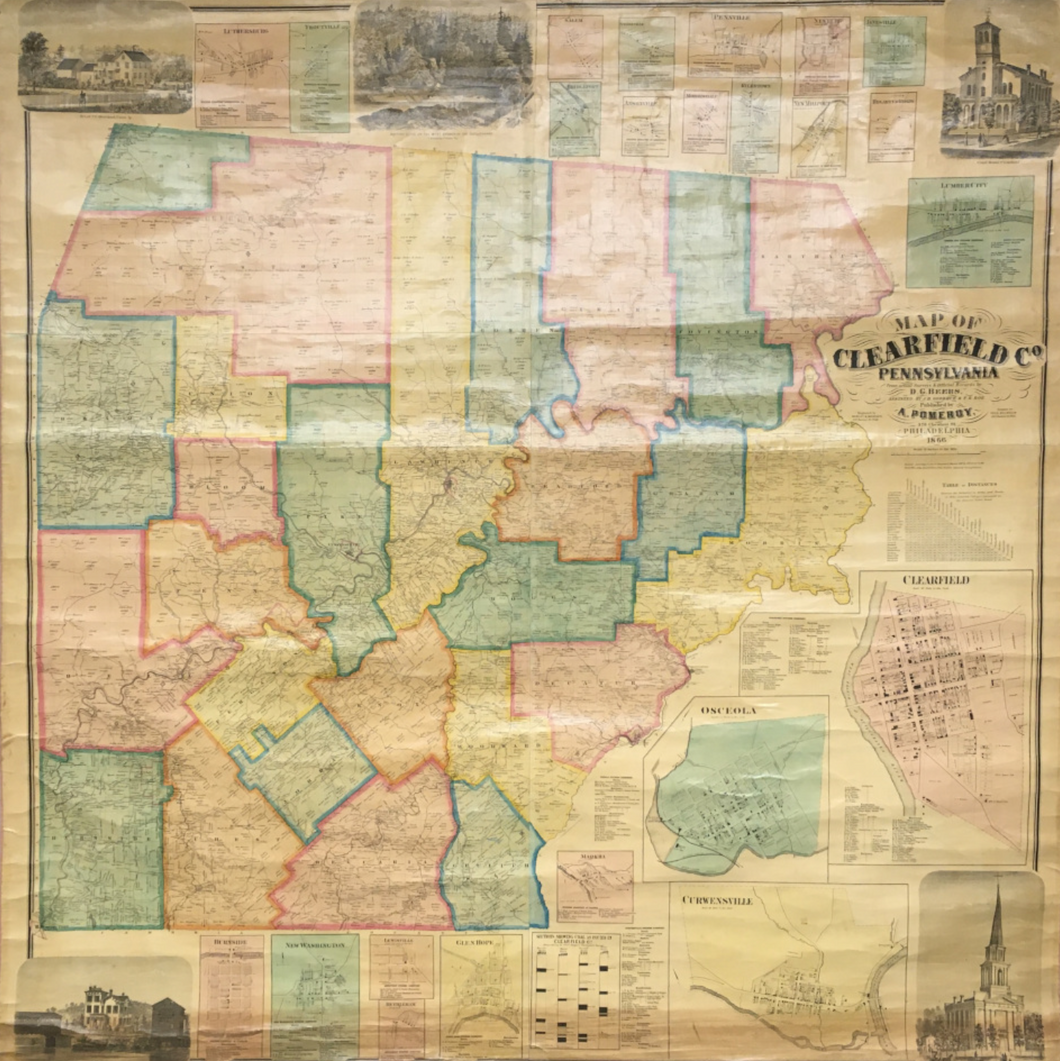


Daniel G. Beers. “Map of Clearfield County, Pennsylvania”.
Philadelphia: A. Pomeroy: 1866. Lithograph by Frederick Bourquin. Original hand color. Mounted to linen and varnished as originally issued. Tears at top of map repaired and creases reinforced with acid free linen tape. Small areas of map surface and margins at top filled and in-painted. Some cracking in map surface at top as to be expected. Map is very clean and exceptionally bright for a varnished map. With old rollers. Else, very good condition.
A large and detailed county map of Clearfield County showing rural buildings, householders' names, warranty-deed tracts, tract numbers, warrantees' names, and tract acreages. The borough insets show real-property tracts (lots), owners' names, and building coverage; the village insets show houses and householders' names. In addition, various borough and village insect maps depict: Clearfield; Osceola; Curwensville; Madera; Glen Hope; Lewisville; Bethleham [sic]; New Washington; Burnside; Luthersburg; Troutville; Salem; Bridgeport; Stoneville; Ansonville; Pennville; Morrisdale; Kylertown; Newburg; New Millport; Janesville and Lumber City.
This wall map may have been displayed in a school, business, real estate or city office, or in a home for decorative purposes. Most wall maps were glued to a linen base and varnished to protect the surface. Over time, the varnish causes the paper to become brown and brittle and the action of rolling and unrolling them results in the paper becoming cracked and chipped. These large maps were never framed and when not needed were often deposited in basements or attics where they would come in contact with water. Most antique wall maps today are usually found with large tide marks and numerous cracks and chips. This map does exhibit some of the anticipated condition problems as described above, but these flaws are as to be expected and all of the cartographic information of the county is intact. Overall, a very scarce and attractive wall map of this county.

 %20%0A%20%0Ahttps://philaprintshop.com/products/beers-daniel-g-map-of-clearfield-county-pennsylvania %20%0A%20%0ABeers,%20Daniel%20G.%20%20%E2%80%9CMap%20of%20Clearfield%20County,%20Pennsylvania%E2%80%9D %20%0A%20%0A//philaprintshop.com/cdn/shop/products/ScreenShot2021-07-22at3.38.15PM_1024x1024.png?v=1626990077 %20%0A%20%0AAntique Prints, Maps, Drawings, Paintings and Rare Books! %20%0A%20%0AThe Philadelphia Print Shop %20%0A106 E. Lancaster Avenue, Lower Level %20%0AWayne, PA 19087 %20%0A%20%0APhilaPrintShop.com %20%0A@PhiladelphiaPrintShop %20%0A 610 (808) 6165)