


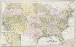
W. Williams. "No. 5. Map of the United States." From Mitchell's School and Family Geography.
Philadelphia: S.A. Mitchell, [1852-]1854. 10 5/8 x 16 7/8. Lithographic transfer from engraved plate by W. Williams. Original hand color wash. Some scattered spots, manuscript in margins & light wear. Overall, good condition.
An excellent map of the United States from S. Augustus Mitchell's influential School Atlas. The maps shows the continental U.S. with good detail throughout, including a large Nebraska Territory reaching all the way to the Canadian border. The map depicts topographical information with clear precision, marking towns, rivers, roads, and counties. Other interesting features abound, including indications of mines, forts and Indian tribes.
 %20%0A%20%0Ahttps://philaprintshop.com/products/williams-w-no-5-map-of-the-united-states %20%0A%20%0AWilliams,%20W.%20%22No.%205.%20Map%20of%20the%20United%20States%22 %20%0A%20%0A//philaprintshop.com/cdn/shop/products/mitchellschoolusc_1024x1024.jpg?v=1651859999 %20%0A%20%0AAntique Prints, Maps, Drawings, Paintings and Rare Books! %20%0A%20%0AThe Philadelphia Print Shop %20%0A106 E. Lancaster Avenue, Lower Level %20%0AWayne, PA 19087 %20%0A%20%0APhilaPrintShop.com %20%0A@PhiladelphiaPrintShop %20%0A 610 (808) 6165)