


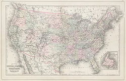
W. Williams. “Map of the United States and Territories with Canada.” From Mitchell’s New General Atlas.
Philadelphia: W.M. Bradley & Bro., 1886. 13 ½ x 21 3/8 (neat lines). Lithograph. Original hand color. Two small repaired tears along centerfold on verso. Else, very good condition.
A precisely detailed map from the Philadelphia publishing firm of William M. Bradley & Bro. Bradley took over the publication of Mitchell’s New General Atlas in the early 1880s and used Mitchell lithographic plate to produce this fine example of nineteenth century American mapmaking. It shows the states with impressive detail, with emphasis on rivers, towns, and the myriad railroad lines crisscrossing the country.
 %20%0A%20%0Ahttps://philaprintshop.com/products/williams-w-map-of-the-united-states-and-territories-with-canada %20%0A%20%0AWilliams,%20W.%20%20%E2%80%9CMap%20of%20the%20United%20States%20and%20Territories%20with%20Canada%22 %20%0A%20%0A//philaprintshop.com/cdn/shop/products/bradleymitchellus1886c_1024x1024.jpg?v=1652976968 %20%0A%20%0AAntique Prints, Maps, Drawings, Paintings and Rare Books! %20%0A%20%0AThe Philadelphia Print Shop %20%0A106 E. Lancaster Avenue, Lower Level %20%0AWayne, PA 19087 %20%0A%20%0APhilaPrintShop.com %20%0A@PhiladelphiaPrintShop %20%0A 610 (808) 6165)