


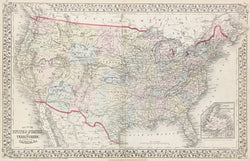
S.A. Mitchell Jr. "Map of The United States, and Territories. Together With Canada &c." From A New General Atlas.
Philadelphia: S.A. Mitchell, Jr. 1874. Lithograph. Original hand color. 13 ¼ x 21 ¼. With decorative grape vine border. Old tape with glue stain in bottom margin not affecting image. Very good condition.
The shape of the Wyoming Territory has taken on its present day shape with Idaho and Utah ceding their eastern portions of land to Wyoming in 1868 thus forming the new Territory of Wyoming. Yellowstone National Park is indicated in the upper left hand corner of Wyoming which was created in 1872. The Dakotah and Indian Territories are indicated.
 %20%0A%20%0Ahttps://philaprintshop.com/products/mitchell-jr-s-a-map-of-the-united-states-and-territories-together-with-canada-c-1874 %20%0A%20%0AMitchell%20Jr.,%20S.A.%20%22Map%20of%20The%20United%20States,%20and%20Territories.%20Together%20With%20Canada%20%26c.%22%201874 %20%0A%20%0A//philaprintshop.com/cdn/shop/products/mitchellus1874c_1024x1024.jpg?v=1652892686 %20%0A%20%0AAntique Prints, Maps, Drawings, Paintings and Rare Books! %20%0A%20%0AThe Philadelphia Print Shop %20%0A106 E. Lancaster Avenue, Lower Level %20%0AWayne, PA 19087 %20%0A%20%0APhilaPrintShop.com %20%0A@PhiladelphiaPrintShop %20%0A 610 (808) 6165)