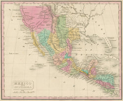
After Conrad Malte-Brun. “Mexico and Guatimala.” [American Southwest & West].
From A New General Atlas. Philadelphia: Grigg & Elliot, 1832. 8 x 9 ¾. Engraving by J.H. Young. Full original hand color. Full margins. Very good condition. A/A
In 1832, Philadelphia publishers Grigg & Elliot issued their New General Atlas. This was intended to illustrate Danish geographer Conrad Malte-Brun’s Universal Geography. The maps are well engraved by J.H.Young, and hand colored in the style of the period.
At that time most of the present-day southwestern United States was part of Mexico and this map nicely shows what was known of the area at the time. Towns, rivers, mountains, and political divisions are indicated, and the hand coloring makes this map as attractive as it is informative. This is a fine map of Mexico, but also California, Nevada, Utah, Colorado, Arizona, New Mexico, and Texas at an early stage of their developments.

![Malte-Brun, Conrad “Mexico and Guatimala” [American Southwest & West]](http://philaprintshop.com/cdn/shop/files/maltebrunmexicothmb_{width}x.jpg?v=1716484778)
![Malte-Brun, Conrad “Mexico and Guatimala” [American Southwest & West]](http://philaprintshop.com/cdn/shop/files/maltebrunmexico_{width}x.jpg?v=1716484786)
![Load image into Gallery viewer, Malte-Brun, Conrad “Mexico and Guatimala” [American Southwest & West]](http://philaprintshop.com/cdn/shop/files/maltebrunmexicothmb_110x110@2x.jpg?v=1716484778)
![Load image into Gallery viewer, Malte-Brun, Conrad “Mexico and Guatimala” [American Southwest & West]](http://philaprintshop.com/cdn/shop/files/maltebrunmexico_110x110@2x.jpg?v=1716484786)
