

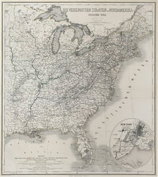
Th. Luther. “Die Vereinigten Staaten von Nordamerika. Osterlicher Theil.” With an oval inset of “New York und seine Umgebungen.”
Weimar: Geographical Institute, [1858]. 25 x 22. Lithograph. Original outline hand color. Very good condition. Ref.: Phillips, Maps, p. 907.
A very detailed map of the eastern half of what was then the developed half of the United States. Railways and waterways are emphasized along with names of cities and towns and topography shown through the hatchuring method. The Geographisches Institut in Weimar existed as early as the first decade of the nineteenth century when it issued some atlases, and it continued well into the second half of the century. A splendid map just prior to the American Civil War.
 %20%0A%20%0Ahttps://philaprintshop.com/products/luther-th-die-vereinigten-staaten-von-nordamerika-osterlicher-theil-with-an-oval-inset-of-new-york-und-seine-umgebungen %20%0A%20%0ALuther,%20Th.%20%20%E2%80%9CDie%20Vereinigten%20Staaten%20von%20Nordamerika.%20Osterlicher%20Theil.%E2%80%9D%20With%20an%20oval%20inset%20of%20%E2%80%9CNew%20York%20und%20seine%20Umgebungen%22 %20%0A%20%0A//philaprintshop.com/cdn/shop/products/lutherunitedstates1858_1024x1024.jpg?v=1651862098 %20%0A%20%0AAntique Prints, Maps, Drawings, Paintings and Rare Books! %20%0A%20%0AThe Philadelphia Print Shop %20%0A106 E. Lancaster Avenue, Lower Level %20%0AWayne, PA 19087 %20%0A%20%0APhilaPrintShop.com %20%0A@PhiladelphiaPrintShop %20%0A 610 (808) 6165)