


Frank A. Gray. “Gray’s New Map of the United States.”
Philadelphia: O.W. Gray, ca. 1890. 16 ¾ x 27 ½. Lithograph. Original hand color. Very good condition.
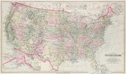
A nicely detailed map by the Philadelphia firm of O.W. Gray and Son. The firm began its publishing around mid-century and produced regional and U.S. atlases up to the 1880s. This map is typical of their work, and its attractive presentation and interesting detail make it a nice example of late nineteenth century Philadelphia cartography. There are two inset maps of Alaska and a Sketch Exhibiting the Westward movement of the center of Population. This map shows the newly admitted states of South and North Dakota and the newly created territory of Oklahoma from Indian Territory.
 %20%0A%20%0Ahttps://philaprintshop.com/products/gray-frank-a-gray-s-new-map-of-the-united-states-c-1890 %20%0A%20%0AGray,%20Frank%20A.%20%20%E2%80%9CGray%E2%80%99s%20New%20Map%20of%20the%20United%20States%22%20c.%201890 %20%0A%20%0A//philaprintshop.com/cdn/shop/products/grayus1890c_1024x1024.jpg?v=1652973931 %20%0A%20%0AAntique Prints, Maps, Drawings, Paintings and Rare Books! %20%0A%20%0AThe Philadelphia Print Shop %20%0A106 E. Lancaster Avenue, Lower Level %20%0AWayne, PA 19087 %20%0A%20%0APhilaPrintShop.com %20%0A@PhiladelphiaPrintShop %20%0A 610 (808) 6165)