


Frank A. Gray. “Gray’s New Map of the United States.”
Philadelphia: O.W. Gray, 1881. 16 ¾ x 27 ½. Lithograph. Original hand color. Chip in bottom margin. Old tape on verso. Small chip in bottom margin. Very good condition.
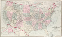
A nicely detailed map by the Philadelphia firm of O.W. Gray and Son. The firm began its publishing around mid-century and produced regional and U.S. atlases up to the 1880s. This map is typical of their work, and its attractive presentation and interesting detail make it a nice example of late nineteenth century Philadelphia cartography. There are two inset maps of Alaska and a Sketch Exhibiting the Westward movement of the center of Population. Also shown is the Dakota Territory and all of present day Oklahoma as “Indian Territory.”
 %20%0A%20%0Ahttps://philaprintshop.com/products/gray-frank-a-gray-s-new-map-of-the-united-states %20%0A%20%0AGray,%20Frank%20A.%20%20%E2%80%9CGray%E2%80%99s%20New%20Map%20of%20the%20United%20States%22 %20%0A%20%0A//philaprintshop.com/cdn/shop/products/grayus1881c_1024x1024.jpg?v=1652973430 %20%0A%20%0AAntique Prints, Maps, Drawings, Paintings and Rare Books! %20%0A%20%0AThe Philadelphia Print Shop %20%0A106 E. Lancaster Avenue, Lower Level %20%0AWayne, PA 19087 %20%0A%20%0APhilaPrintShop.com %20%0A@PhiladelphiaPrintShop %20%0A 610 (808) 6165)