


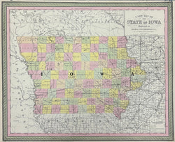
"A New Map of the State of Iowa." From Universal Atlas.
Philadelphia: Thomas, Cowperthwait & Co., 1854. 15 3/4 x 13. Lithograph transfer from engraved plate. Original hand-coloring. Very good condition.
A strong, beautifully crafted map of Iowa from the mid-nineteenth century, published by Thomas, Cowperthwait & Co. This firm took over the publication of S. Augustus Mitchell's important Universal Atlas in 1850, and they continued to produce up-dated maps that were amongst the best issued in the period. This map shows a state beginning to come into its own, with development throughout the state. The maps issued by Thomas, Cowperthwait & Co. are known for their depiction of transportation systems and this map is no exception. The burgeoning network of roads and railroads is clearly depicted, connecting the many towns throughout this prosperous state. An excellent picture of Iowa at mid-century.
 %20%0A%20%0Ahttps://philaprintshop.com/products/thomas-cowperthwait-co-a-new-map-of-the-state-of-iowa %20%0A%20%0AThomas,%20Cowperthwait%20%26%20Co.%20%22A%20New%20Map%20of%20the%20State%20of%20Iowa%22 %20%0A%20%0A//philaprintshop.com/cdn/shop/files/cowp54iowac_1024x1024.jpg?v=1700602424 %20%0A%20%0AAntique Prints, Maps, Drawings, Paintings and Rare Books! %20%0A%20%0AThe Philadelphia Print Shop %20%0A106 E. Lancaster Avenue, Lower Level %20%0AWayne, PA 19087 %20%0A%20%0APhilaPrintShop.com %20%0A@PhiladelphiaPrintShop %20%0A 610 (808) 6165)