


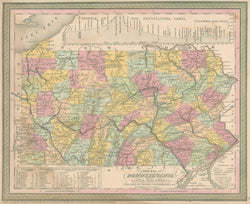
Thomas, Cowperthwait & Co. "A New Map of Pennsylvania with its Canals, Rail-roads &c."
Philadelphia: Thomas, Cowperthwait & Co., 1850. 11 3/4 x 14 1/4. Lithographic transfer from engraved plate. Full original color. light staining in bottom margin and into table, bottom left; tiny spots in margins. Else, very good condition.
A strong and beautifully crafted map of Pennsylvania from the mid-nineteenth century, published by Thomas, Cowperthwait & Co. This firm took over the publication of S. Augustus Mitchell's important Universal Atlas in 1850, and they continued to produce updated maps that were amongst the best issued in the period.
 %20%0A%20%0Ahttps://philaprintshop.com/products/thomas-cowperthwait-co-a-new-map-of-pennsylvania-with-its-canals-rail-roads %20%0A%20%0AThomas,%20Cowperthwait%20%26%20Co.%20%22A%20New%20Map%20of%20Pennsylvania%20with%20its%20Canals,%20Rail-roads%20%26c.%22 %20%0A%20%0A//philaprintshop.com/cdn/shop/products/cowp50pac_1024x1024.jpg?v=1660145609 %20%0A%20%0AAntique Prints, Maps, Drawings, Paintings and Rare Books! %20%0A%20%0AThe Philadelphia Print Shop %20%0A106 E. Lancaster Avenue, Lower Level %20%0AWayne, PA 19087 %20%0A%20%0APhilaPrintShop.com %20%0A@PhiladelphiaPrintShop %20%0A 610 (808) 6165)