


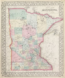
S. Augustus Mitchell, Jr. "County Map of Minnesota." From Mitchell's New General Atlas.
Philadelphia: S. Augustus Mitchell, Jr., 1867. 13 7/8 x 11 5/8. Lithograph. Original hand color. Very good condition.
S.Augustus Mitchell, Jr., of Philadelphia, was one of the largest map publishers of the middle of the nineteenth century. The firm was founded by his father, who from the middle of the nineteenth century, issued atlases and maps of all parts of the world in all formats. The Mitchell atlases contained up-to-date maps which were as attractive as they were accurate. This is a fine example of the Mitchell firm's output. Interestingly, this map shows one inconsistency, with Rock County labeled as Pipestone, and vice versa. Both counties were founded in May of 1857. This error seems to have begun in an earlier published map of the state by Colton.
 %20%0A%20%0Ahttps://philaprintshop.com/products/mitchell-s-augustus-jr-county-map-of-minnesota-1867 %20%0A%20%0AMitchell,%20S.%20Augustus%20Jr.%20%20%E2%80%9CCounty%20Map%20of%20Minnesota%E2%80%9D%201867 %20%0A%20%0A//philaprintshop.com/cdn/shop/files/mitchellmn1867c_1024x1024.jpg?v=1686162202 %20%0A%20%0AAntique Prints, Maps, Drawings, Paintings and Rare Books! %20%0A%20%0AThe Philadelphia Print Shop %20%0A106 E. Lancaster Avenue, Lower Level %20%0AWayne, PA 19087 %20%0A%20%0APhilaPrintShop.com %20%0A@PhiladelphiaPrintShop %20%0A 610 (808) 6165)