


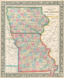
S. Augustus Mitchell, Jr. "County Map of the the States of Iowa and Missouri."
Philadelphia: S. Augustus Mitchell, Jr. 1881. 14 x 11 1/2. Lithograph. Original hand coloring. Decorative floral border. Very good condition.
For most of the middle part of the nineteenth century, the firm founded by S. Augustus Mitchell, Sr. dominated American cartography in output and influence. This fine map is from one of his son's atlases, and it shows Iowa and Missouri in the early 1880s. Towns, rivers, roads and other topographical information are clearly shown, and the counties are shaded with contrasting pastel colors. A fine decorative border surrounds the map, and the whole effect makes for an attractive and historically interesting late-nineteenth century map.
 %20%0A%20%0Ahttps://philaprintshop.com/products/mitchell-s-augustus-county-map-of-the-the-states-of-iowa-and-missouri %20%0A%20%0AMitchell,%20S.%20Augustus%20%E2%80%9CCounty%20Map%20of%20the%20the%20States%20of%20Iowa%20and%20Missouri%E2%80%9D %20%0A%20%0A//philaprintshop.com/cdn/shop/files/mitch81iamoc_1024x1024.jpg?v=1700596793 %20%0A%20%0AAntique Prints, Maps, Drawings, Paintings and Rare Books! %20%0A%20%0AThe Philadelphia Print Shop %20%0A106 E. Lancaster Avenue, Lower Level %20%0AWayne, PA 19087 %20%0A%20%0APhilaPrintShop.com %20%0A@PhiladelphiaPrintShop %20%0A 610 (808) 6165)