


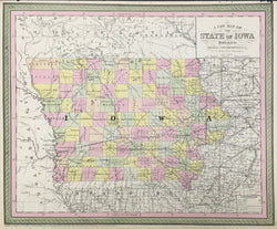
S. Augustus Mitchell. Plate 35. “A New Map of The State of Iowa."
Philadelphia: Thomas, Cowperthwait & Co., 1854. 13 x 15 7/8. Lithographic transfer from engraved plate. Full original color. Narrow margin at top due to original binding, else very good condition.
A strong and beautifully crafted map of Iowa from the mid-nineteenth century, published by Thomas, Cowperthwait & Co. This firm took over the publication of S. Augustus Mitchell's important Universal Atlas in 1850, and they continued to produce up-dated maps that were amongst the best issued in the period. This map shows Iowa at an interesting time in its development. The map is filled with myriad topographical details, including rivers, towns, lakes and political borders. This firm's maps are especially known for their depiction of the transportation routes of the states, and this map is no exception. The transportation infrastructure was extremely important at this period of increased immigration and travel in the American mid-west. This information is clearly depicted, including roads, rail lines - existing, in progress, and proposed - and canals. The map has a striking appearance, with warm hand coloring that well compliments the clear presentation. For its fascinating detail and decorative appeal, this is an excellent Iowa document.
 %20%0A%20%0Ahttps://philaprintshop.com/products/mitchell-s-augustus-a-new-map-of-the-state-of-iowa %20%0A%20%0AMitchell,%20S.%20Augustus%20%20%E2%80%9CA%20New%20Map%20of%20The%20State%20of%20Iowa.%22 %20%0A%20%0A//philaprintshop.com/cdn/shop/products/cowperthwaitiowa1854c_1024x1024.jpg?v=1639518095 %20%0A%20%0AAntique Prints, Maps, Drawings, Paintings and Rare Books! %20%0A%20%0AThe Philadelphia Print Shop %20%0A106 E. Lancaster Avenue, Lower Level %20%0AWayne, PA 19087 %20%0A%20%0APhilaPrintShop.com %20%0A@PhiladelphiaPrintShop %20%0A 610 (808) 6165)