


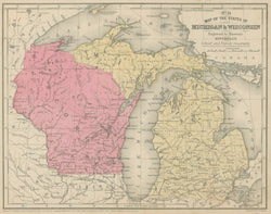
Mitchell, S.A. Sr. "Map of the States of Michigan & Wisconsin." From Mitchell's School and Family Geography.
Philadelphia: S.A. Mitchell Sr., 1851. 8 1/4 x 10 5/8. Lithographic transfer from engraved plate by J.H. Young. Original hand color. Very good condition.
An excellent map of North America from a later edition of Mitchell’s School and Family Geography. The map depicts topographical information with clear precision, marking political divisions, cities, towns, rivers, roads, and counties. Other interesting features abound. Historically and geographically, a fine map from a crucial period of history.
 %20%0A%20%0Ahttps://philaprintshop.com/products/mitchell-s-a-sr-map-of-the-states-of-michigan-wisconsin %20%0A%20%0AMitchell,%20S.A.%20Sr.%20%20%22Map%20of%20the%20States%20of%20Michigan%20%26%20Wisconsin.%22 %20%0A%20%0A//philaprintshop.com/cdn/shop/products/mitchellschoolmiwic_1024x1024.jpg?v=1635612281 %20%0A%20%0AAntique Prints, Maps, Drawings, Paintings and Rare Books! %20%0A%20%0AThe Philadelphia Print Shop %20%0A106 E. Lancaster Avenue, Lower Level %20%0AWayne, PA 19087 %20%0A%20%0APhilaPrintShop.com %20%0A@PhiladelphiaPrintShop %20%0A 610 (808) 6165)