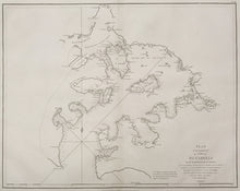
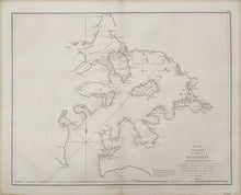
Jean-François Galaup de La Pérouse. "Plan of the Entrance of the Port of Bucarelli on the North West Coast of America, in 55° 15' of Latitude North & 136° 15' of Longitude West of Paris*; Discovered in 1775 by the Spanish Schooner la Senora Commanded by D. Juan Fco. de la Quadra & D. Franco. Anto. Maurelle; and more amply explored in the Expedition of 1779, by the same officers and others of the Spanish Navy." (With note "*This longitude is determined by La Pérouse's chart of the north west coast of America; the Spanish chart from which the present plan has been reduced fixes the longitude of Port Bucarelli at 140°15'.")
London: G.G. & J. Robinson, Paternoster Row, November 1, 1798. 15 x 19 1/4. Copper engraving by Samuel John Neele (1758-1824). Very good condition.
Jean-François de Galaup, Comte de La Pérouse (1741-ca. 1788) entered the French Navy at the age of fifteen and served in action against the British off North America in the Seven Years War. He later served in India and China and became famous when he captured two British forts in Hudson Bay. In 1785 he was appointed to lead an exploratory expedition to the Pacific Ocean using two ships that would become famous: the Astrolabe and the Boussole. Among the crew were an astronomer, a physicist, three naturalists, a mathematician, and a number of draftsmen.
Leaving Brest in 1785 and rounding Cape Horn he visited the Spanish colonies in Chile, Easter Island, Hawaii and Alaska. After losing twenty one of the party in a landing operation, the expedition visited Monterey, California, and then sailed to the South Pacific and Southeast Asia. Sailing next to Kamchatka, he arranged to have manuscripts and drawings by members of the expedition sent across Russia to France where they arrived one year later. The two ships next sailed back to the South Pacific where they disappeared. Many years later evidence was found of the ships being wrecked on reefs and the crews killed by natives. The drawings and maps which survive today in the atlas first published in Paris in 1797 are a tribute and merely an insight into what would have been an enormous cache of information on the Pacific world if the expedition had survived. Subsequent editions of text and atlas were published in English, Dutch, Swedish, and Italian. Interestingly, this map, from the English edition, shows depth soundings.
As the title of the map indicates, Alaska's Bucareli Bay had been named in a 1775 expedition by Juan Francisco de la Bodega y Quadra, commander of the ship Sonora, and in honor of Antonio Maria de Bucareli y Ursúa, the Viceroy of New Spain. To the east the twenty-five mile long bay connects to various waterways, such as San Alberto Bay, and to the west it opens directly to the Pacific Ocean.


