


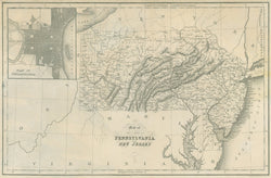
“Map of the States of Pennsylvania and New Jersey” with inset “Plan of Philadelphia.” From John H. Hinton’s The History and Topography of the United States of America. Framed. A/A
London: I.T. Hinton & Simpkin & Marshall, [1830]-1832. Steel engraving by Fenner Sears & Co. With folds as originally issued. Remnants of old paper backing on verso. Very light yellowing of paper upper right hand side. Else, very good condition.
A lovely example of a steel engraving from one of the more popular nineteenth century view and map books, Hinton’s History and Topography. This work contained text and numerous illustrations documenting the history and topography of the United States. Hinton used many different artists, all the engravings being made from drawings made on the spot. For their wide coverage, accurate detail, and pleasing appearance, these are amongst the finest small images of early nineteenth century America to be found anywhere. The London edition was the only one with maps of the regions throughout the United States.
 %20%0A%20%0Ahttps://philaprintshop.com/products/hinton-map-of-the-states-of-pennsylvania-and-new-jersey-with-inset-plan-of-philadelphia %20%0A%20%0AHinton%20%E2%80%9CMap%20of%20the%20States%20of%20Pennsylvania%20and%20New%20Jersey%E2%80%9D%20with%20inset%20%E2%80%9CPlan%20of%20Philadelphia%E2%80%9D %20%0A%20%0A//philaprintshop.com/cdn/shop/products/hintonpac_1024x1024.jpg?v=1679080608 %20%0A%20%0AAntique Prints, Maps, Drawings, Paintings and Rare Books! %20%0A%20%0AThe Philadelphia Print Shop %20%0A106 E. Lancaster Avenue, Lower Level %20%0AWayne, PA 19087 %20%0A%20%0APhilaPrintShop.com %20%0A@PhiladelphiaPrintShop %20%0A 610 (808) 6165)