


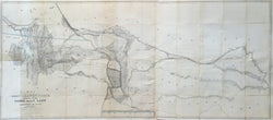
John Williams Gunnison (1812-53) & Charles Preuss (1803-54). “Map of a Reconnoissance between Fort Leavenworth and the Missouri River, and the Great Salt Lake in the Territory of Utah, made in 1849 and 1850.” From H.J. Stansbury’s An Expedition to the Valley of the Great Sale Lake of Utah.
Washington: GPO, 1852. 29 x 68 (neat lines). Lithograph by Ackerman on thin bank note paper. Original outline color. With folds as originally issued. Some time-toning in map and along folds as to be expected. Multiple separations along folds skillfully repaired with acid-free archival tape. All folds reinforced with acid-free archival tape. Numerous small losses of paper along some folds, and where some folds intersect, skillfully filled with matching paper and in-painted. Small grouping of water stains to the right of title. Else, fine condition. With front cover. Wheat: 764.
With the huge number of emigrants crossing the American continent in the 1840s, following the Platte River and across the South Pass on the Oregon Trail, there was a need for a better understanding of this relatively unknown region. Combining this with the growing desire to find a practical route for a transcontinental railroad, in 1849 the U.S. Government commissioned Howard Stansbury, a Captain in the U.S. Topographical Engineers, to survey the trail from Fort Leavenworth west to the Great Salt Lake.
Stansbury’s was the first accurate survey of this route and of the Great Basin around the Great Salt Lake. Some of the map is borrowed from Frémont, who had surveyed the area in 1843, but Stansbury’s party was the first to circumnavigate the lake and much new information is provided throughout. Working with J.W. Gunnison and Charles Preuss, Albert Carrington and others, the full survey from Kansas, across the southern Rockies, and around the Utah Valley took about two years, at the end of which Stansbury submitted his report to Congress in 1852, including this seminal map of the American West.
The detail in the map is remarkable, presented with crisp lithography. Presented with great precision is the topography, including prominent land features, mountain passes, rivers, lakes, and springs, as well as social features such as towns, forts, Indian tribes, and of course, the various trails to Oregon and California and along the base of the Rockies. Stansbury also provided information of the Rocky Mountains down into what would soon become the Colorado Territory, including the three Parks, Pikes Peak and Longs Peak. This is on the best maps of the American West before the Civil War, what Wheat calls “one of the most important of its decade.”
 %20%0A%20%0Ahttps://philaprintshop.com/products/gunnison-john-williams-preuss-charles-map-of-a-reconnoissance-between-fort-leavenworth-and-the-missouri-river-and-the-great-salt-lake-in-the-territory-of-utah-made-in-1849-and-1850 %20%0A%20%0AGunnison,%20John%20Williams%20%26%20Preuss,%20Charles%20%20%E2%80%9CMap%20of%20a%20Reconnoissance%20between%20Fort%20Leavenworth%20and%20the%20Missouri%20River,%20and%20the%20Great%20Salt%20Lake%20in%20the%20Territory%20of%20Utah,%20made%20in%201849%20and%201850%22 %20%0A%20%0A//philaprintshop.com/cdn/shop/files/stansburyc_1024x1024.jpg?v=1687549349 %20%0A%20%0AAntique Prints, Maps, Drawings, Paintings and Rare Books! %20%0A%20%0AThe Philadelphia Print Shop %20%0A106 E. Lancaster Avenue, Lower Level %20%0AWayne, PA 19087 %20%0A%20%0APhilaPrintShop.com %20%0A@PhiladelphiaPrintShop %20%0A 610 (808) 6165)